Index of /data/archief/model/UWCW01/INI_03
Name
Last modified
Size
Description
Parent Directory
-
h43_pcptype_02300.png
2026-04-12 05:40
87K
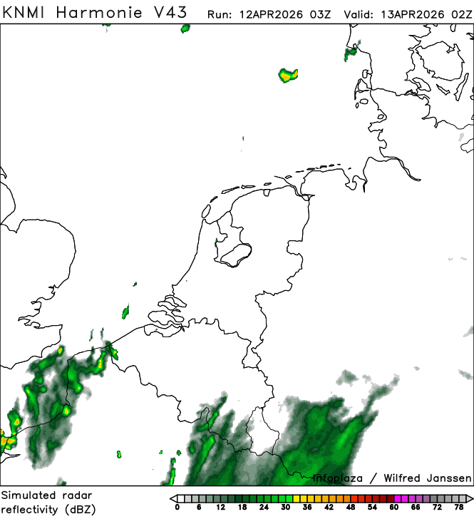
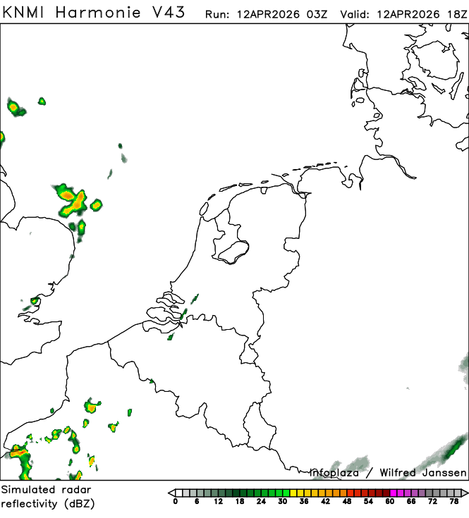
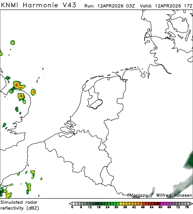
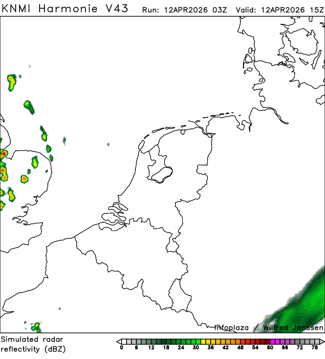
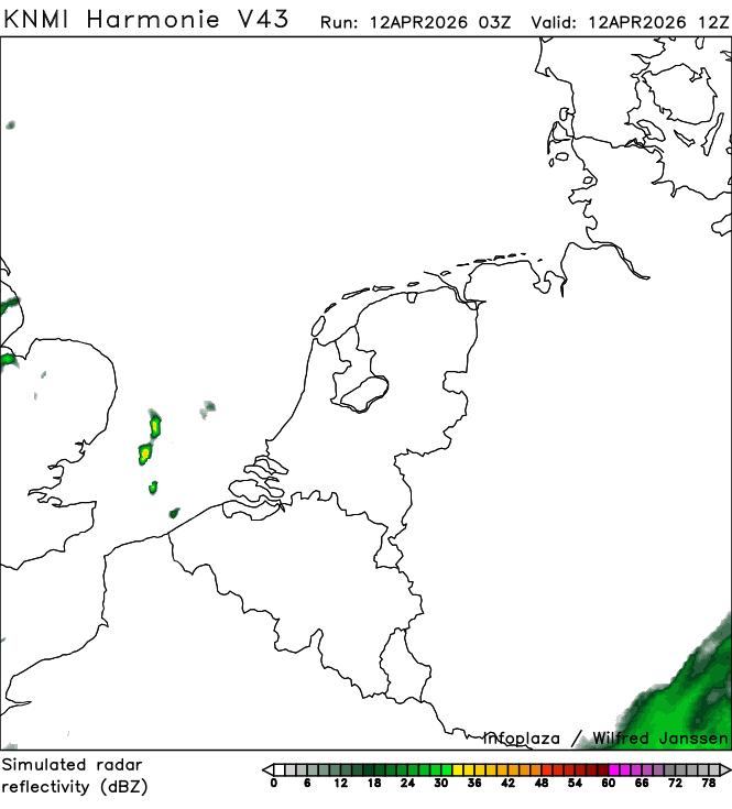
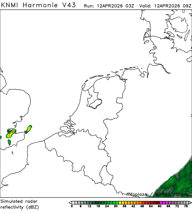
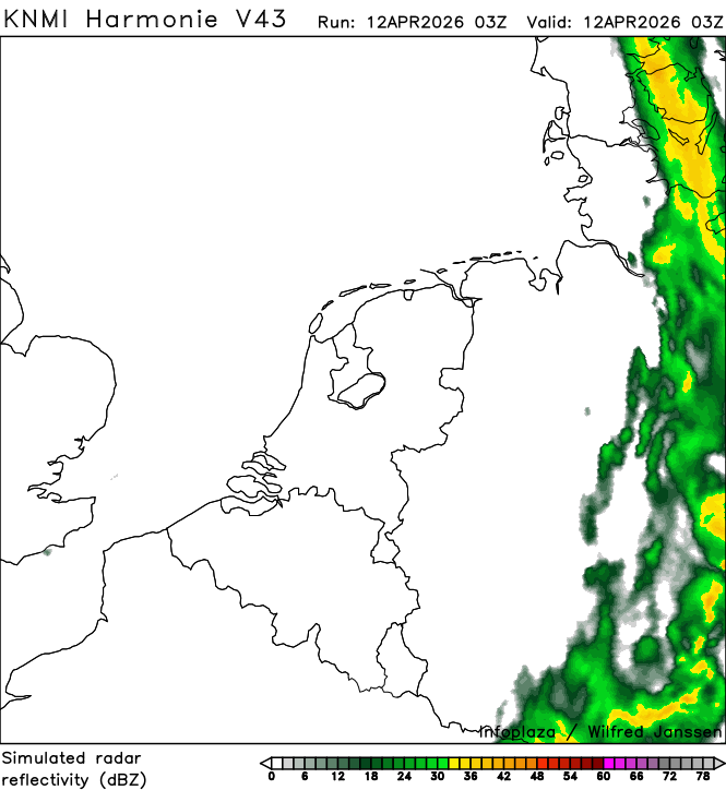
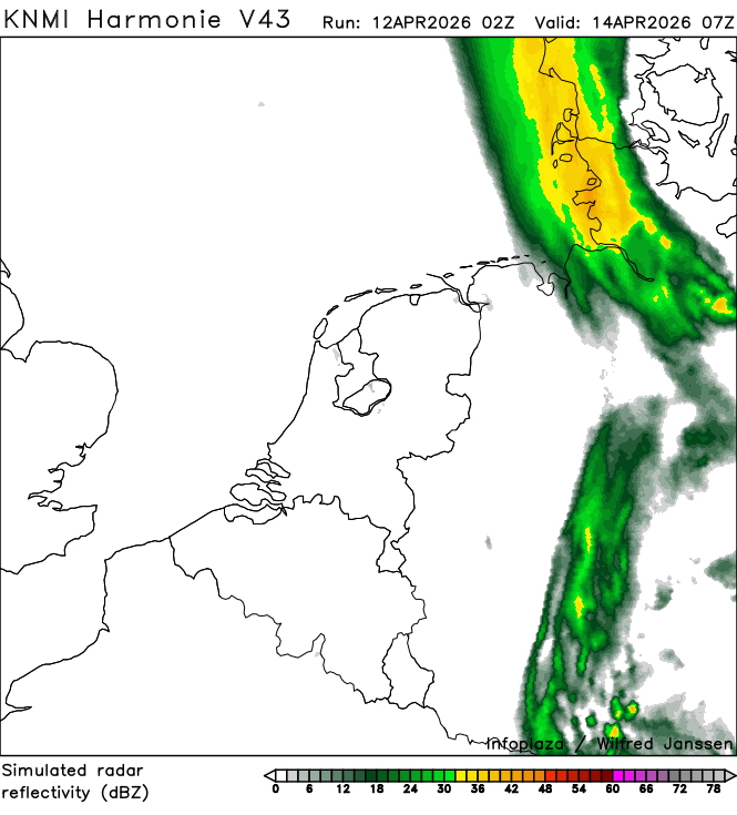
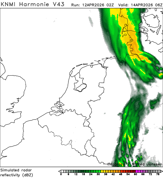
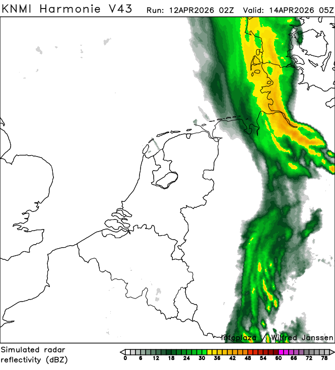
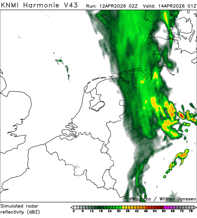
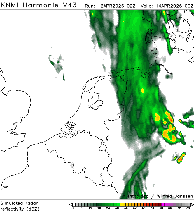
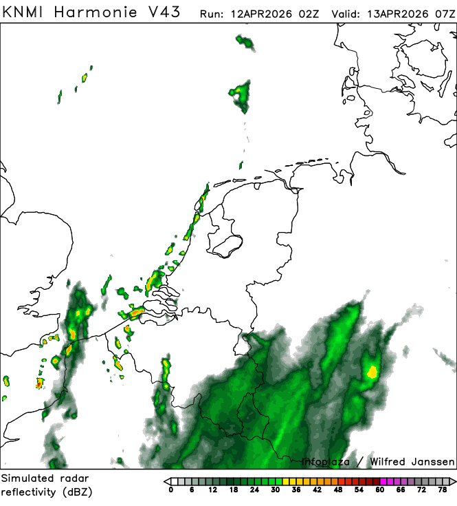
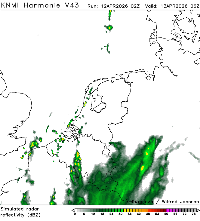
h43_simradar_02300.png
2026-04-12 05:40
101K
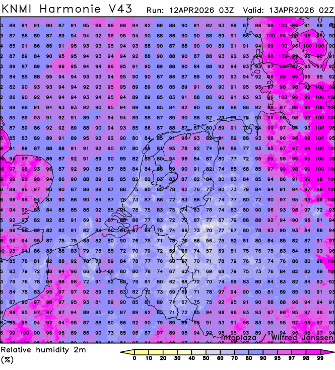
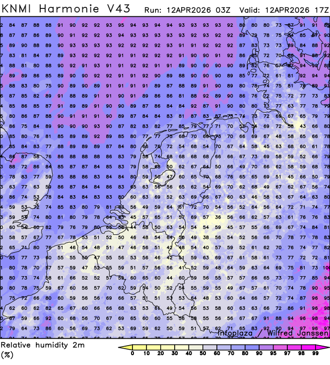
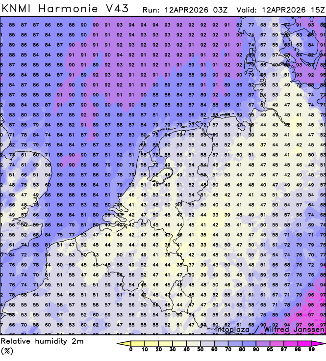
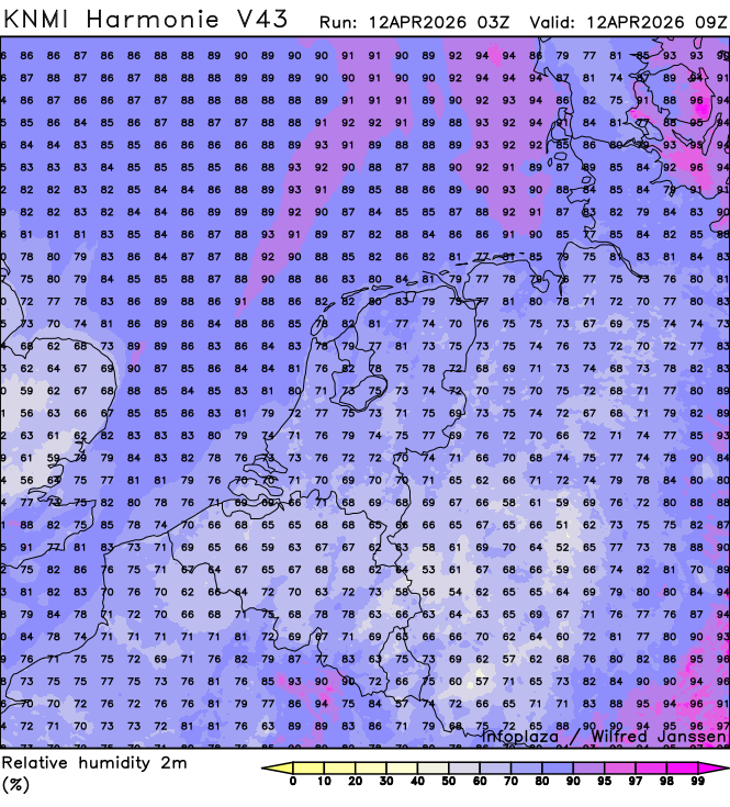
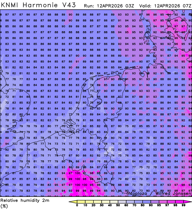
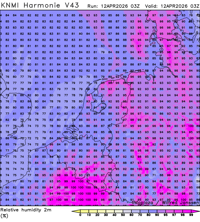
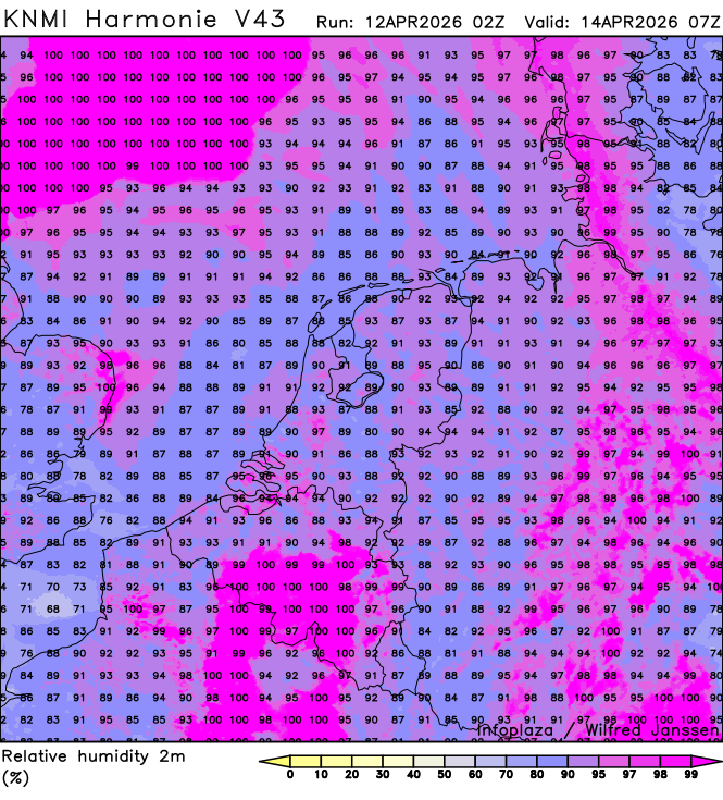
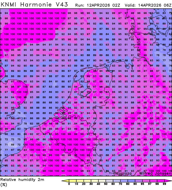
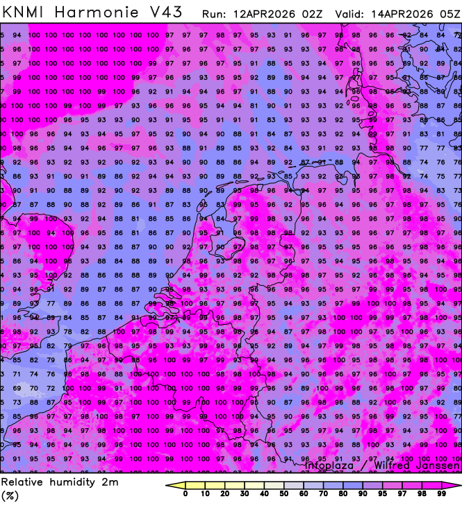
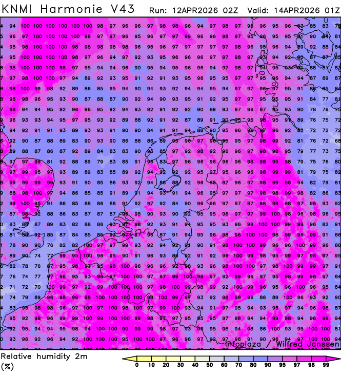
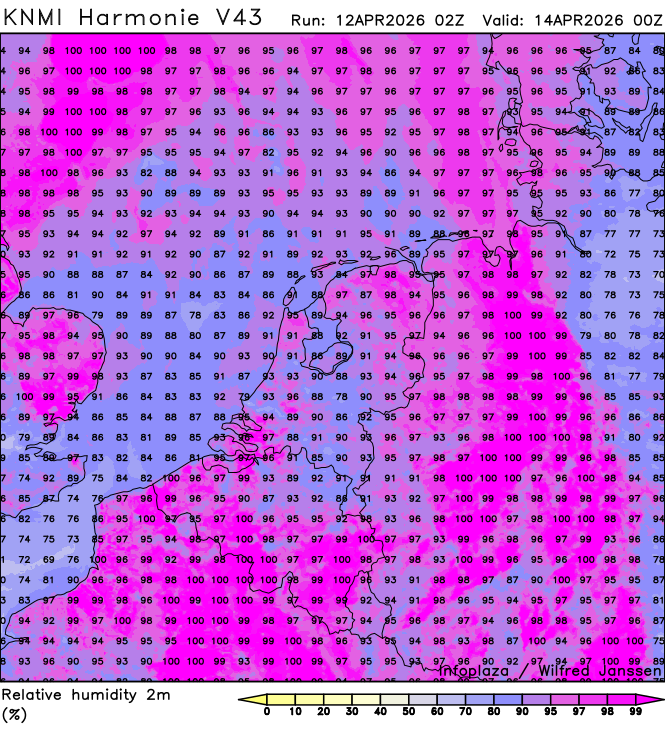
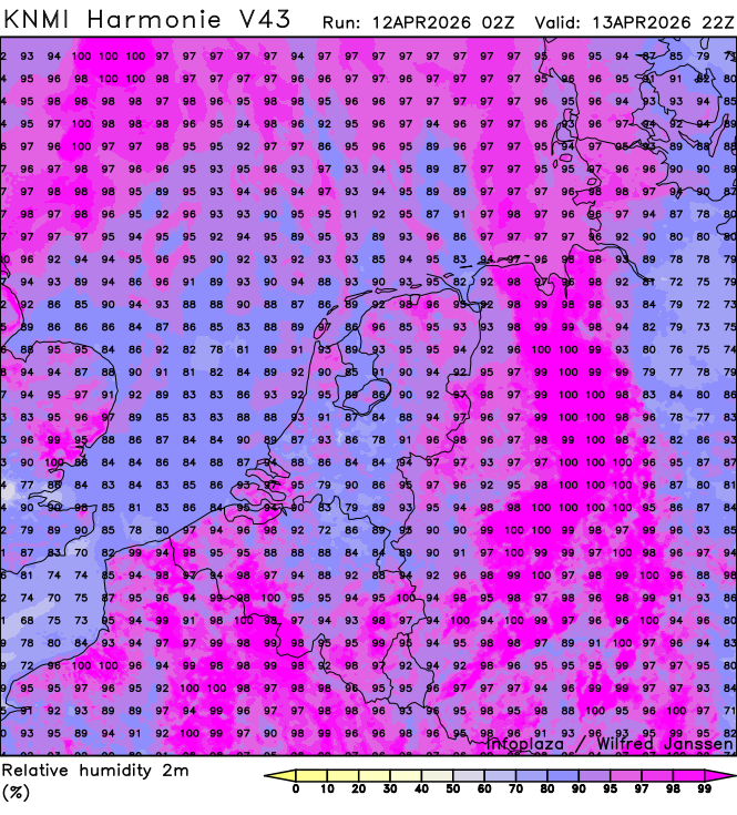
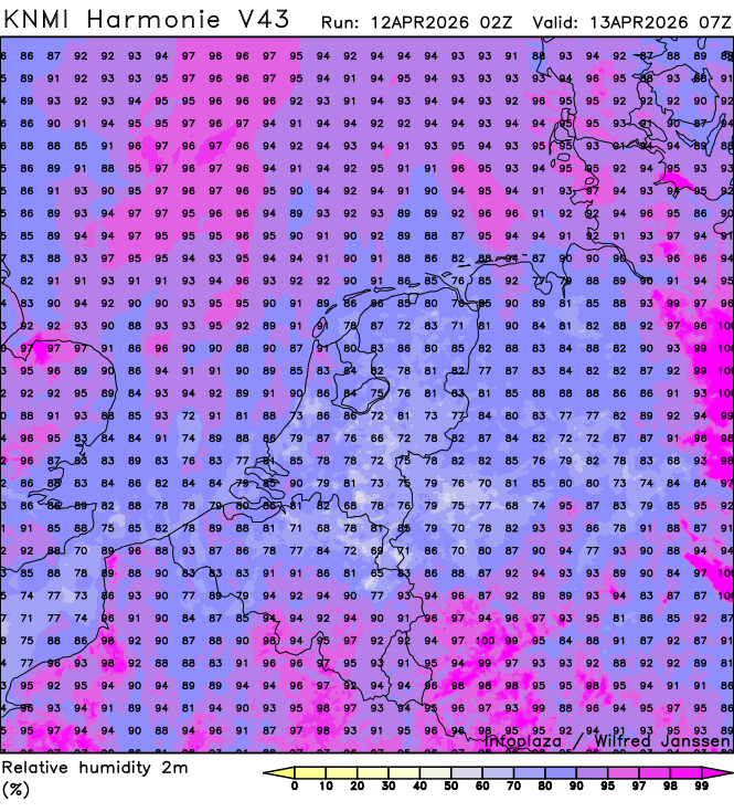
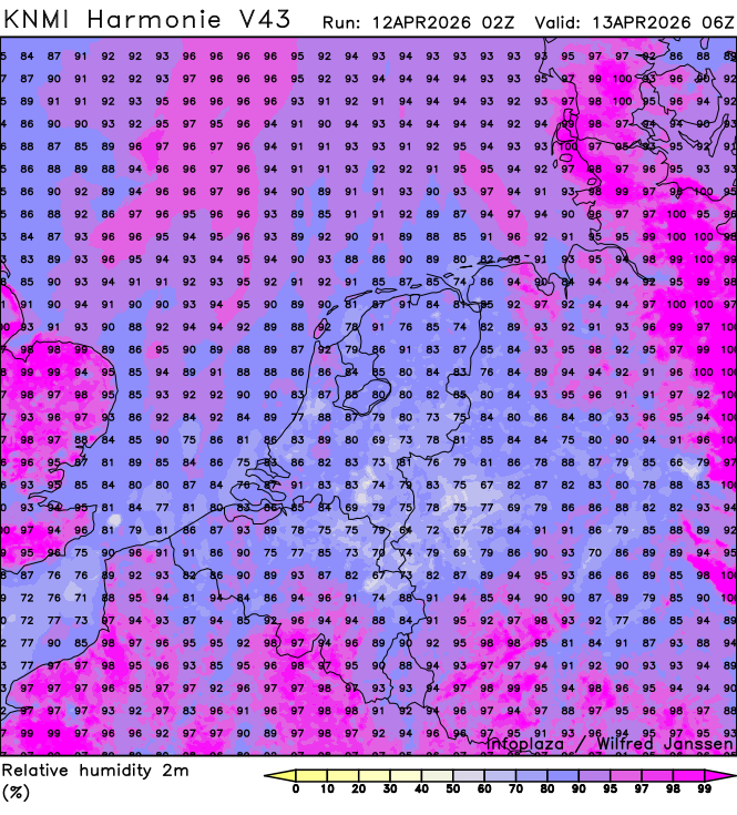
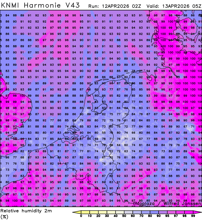
h43_humidity_02300.png
2026-04-12 05:40
353K
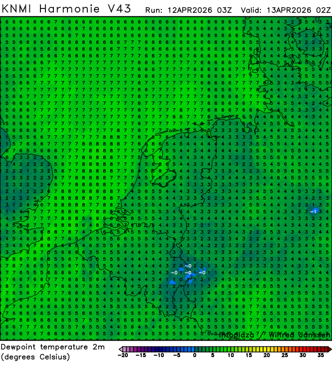
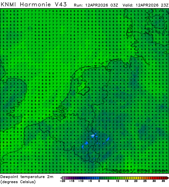
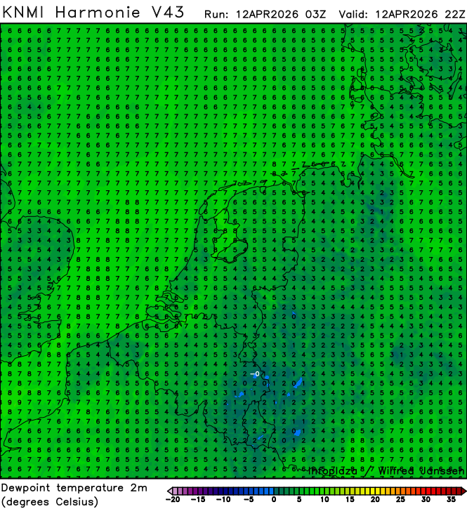
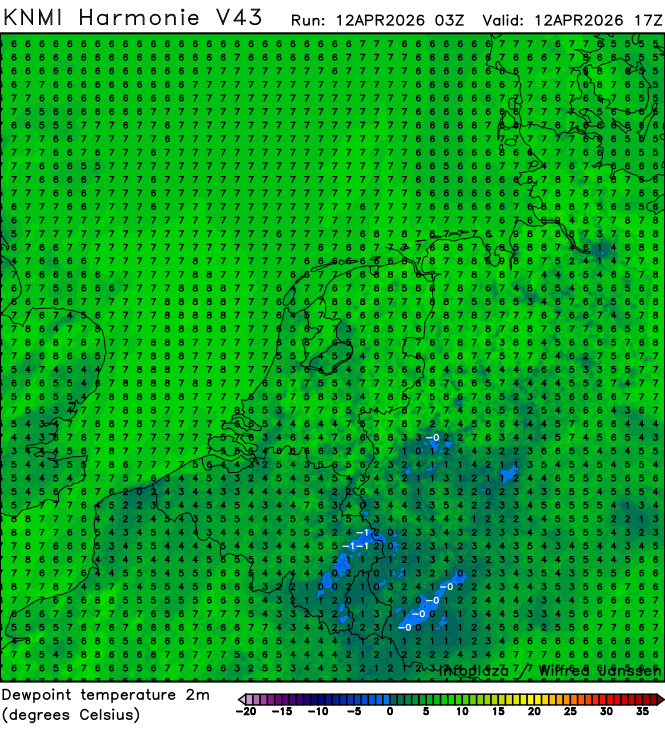
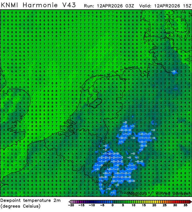
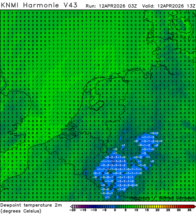
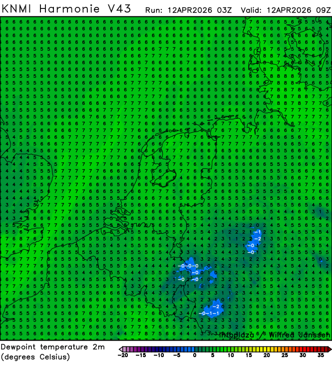
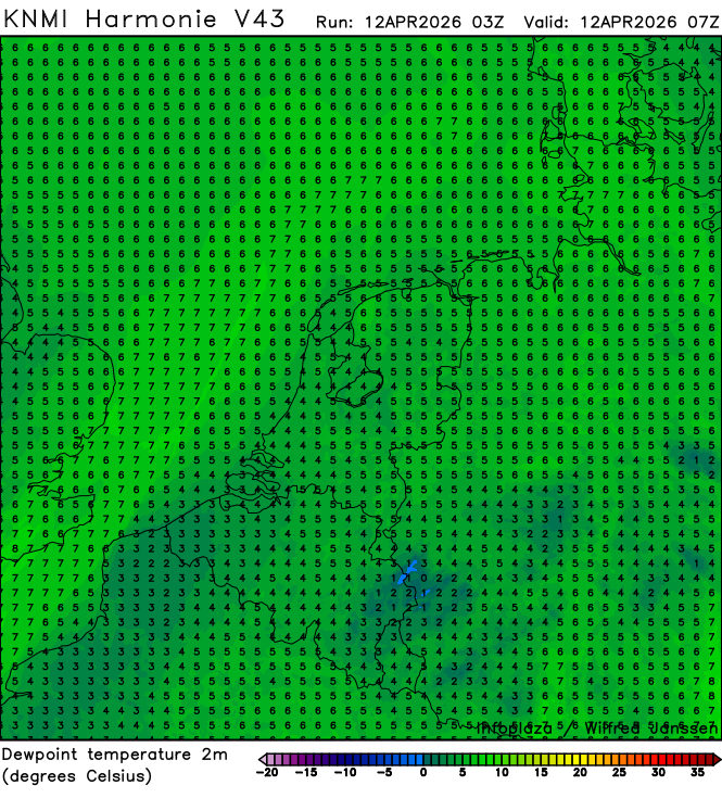
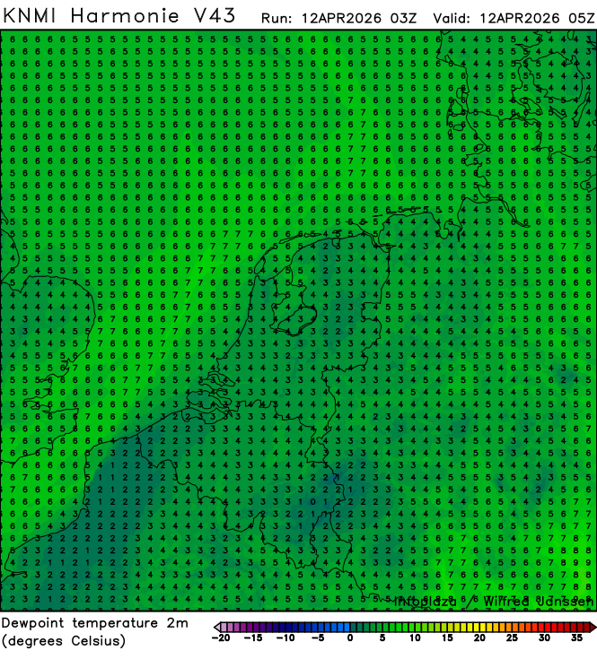
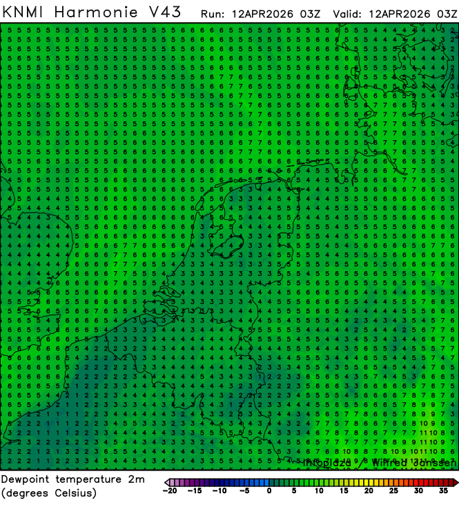
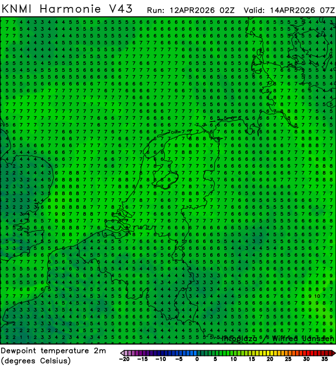
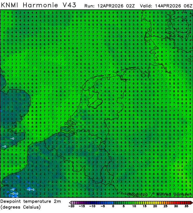
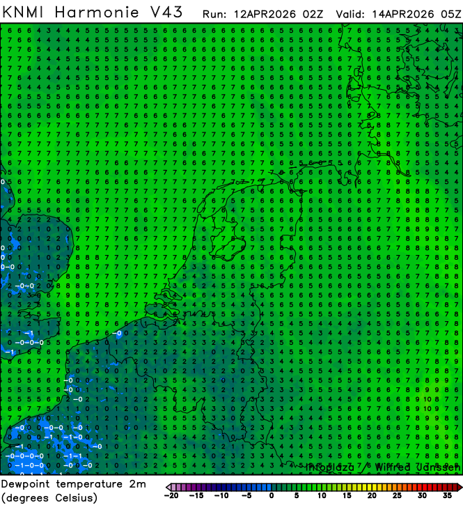
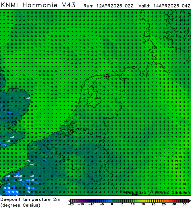
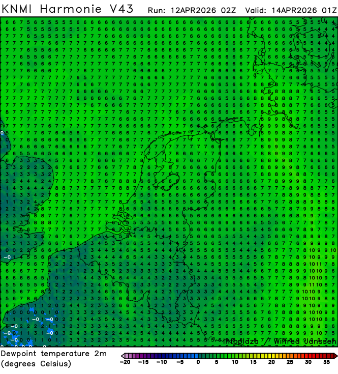
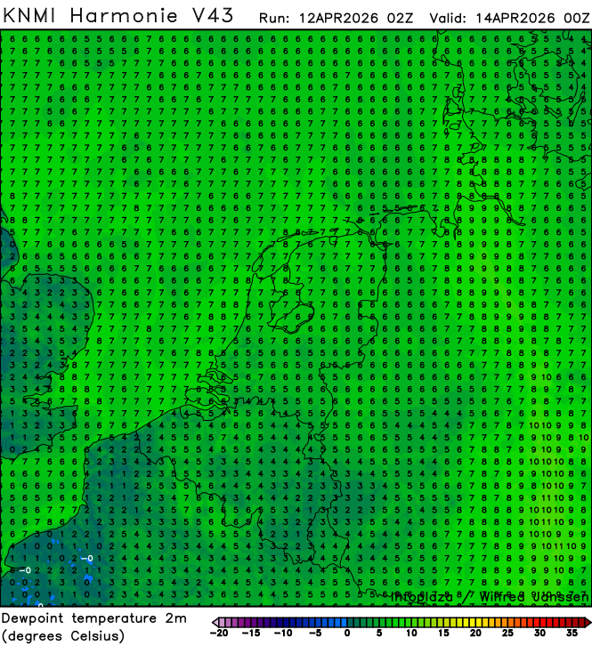
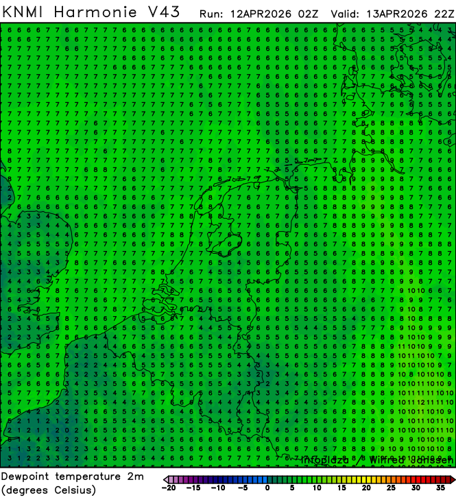
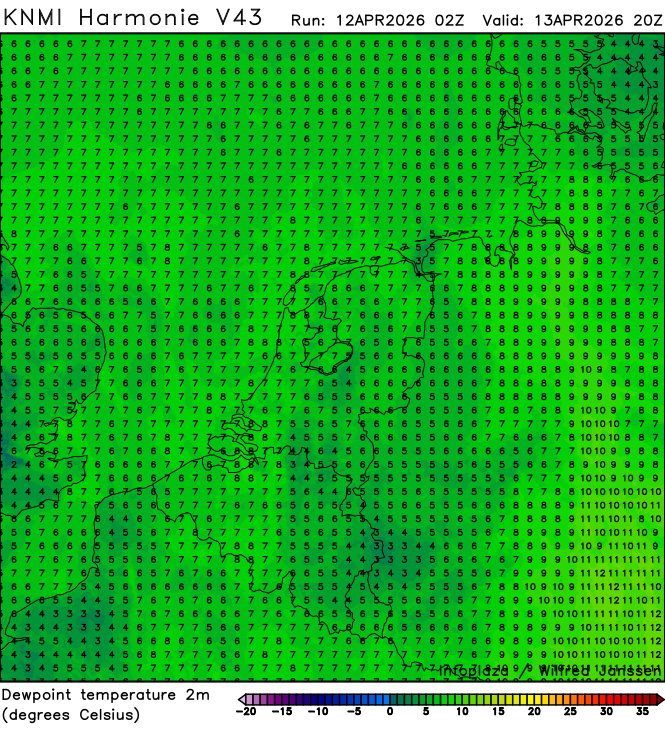
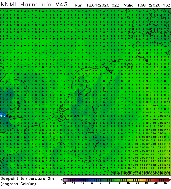
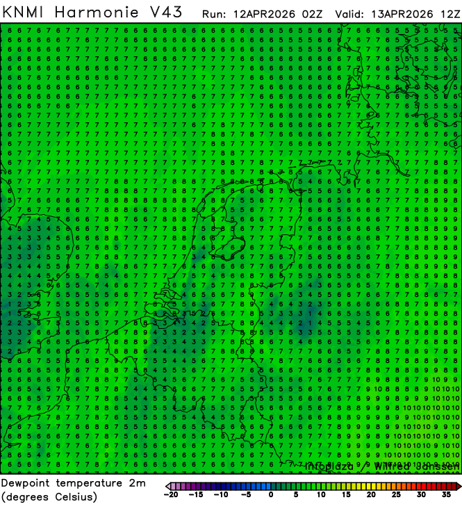
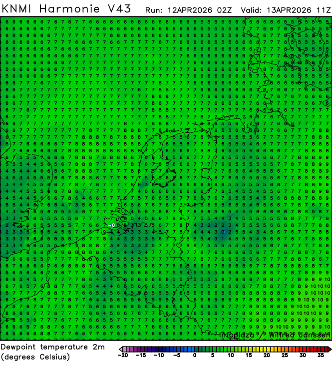
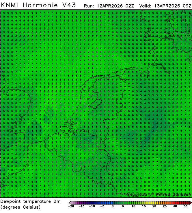
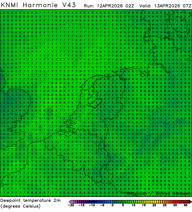
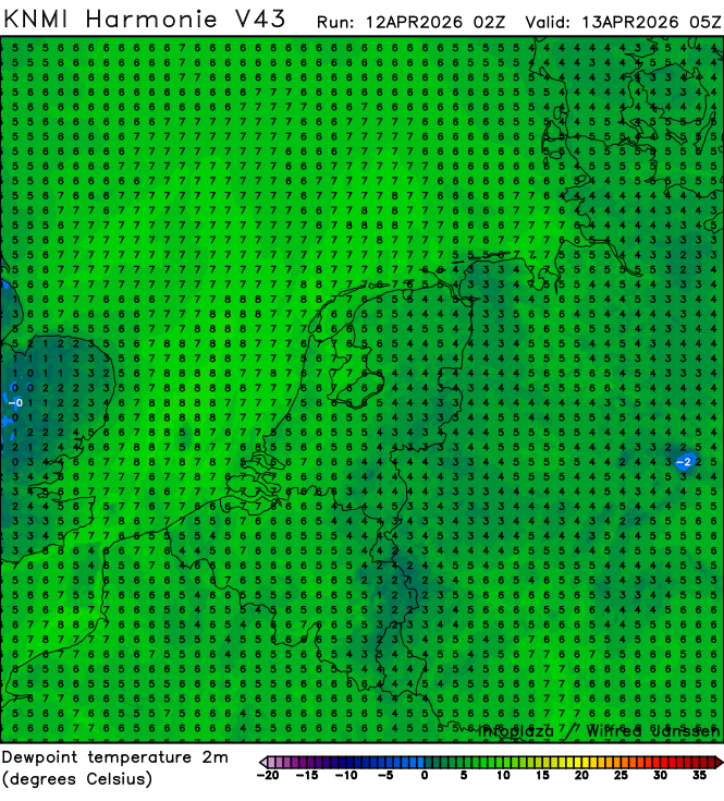
h43_dewpoint2m_02300.png
2026-04-12 05:40
309K
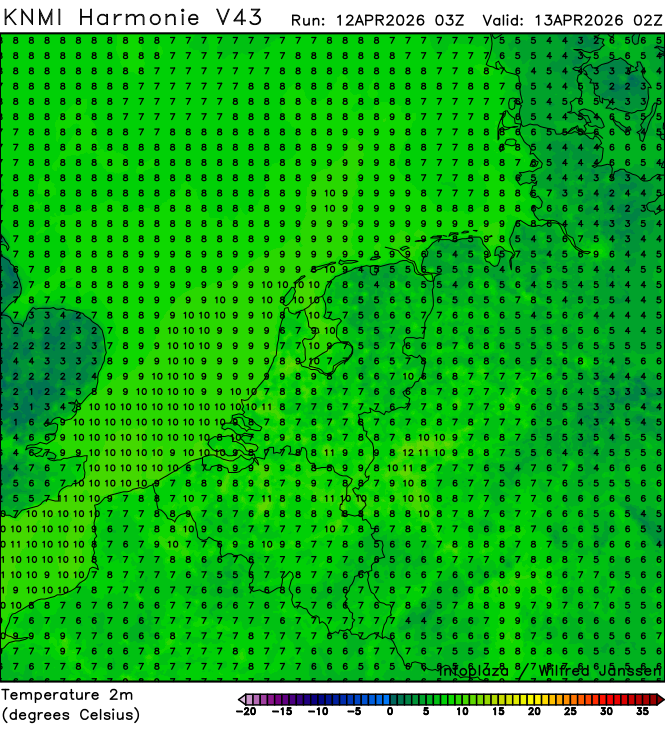
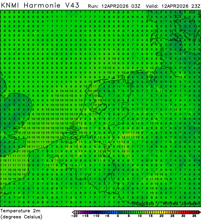
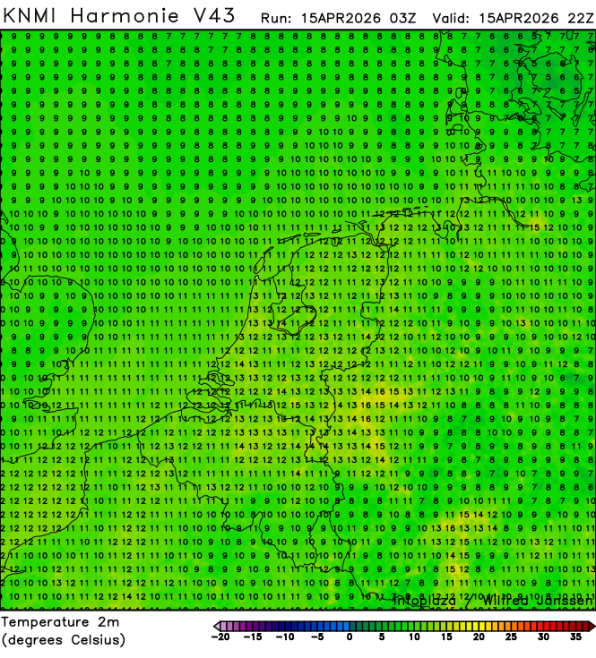
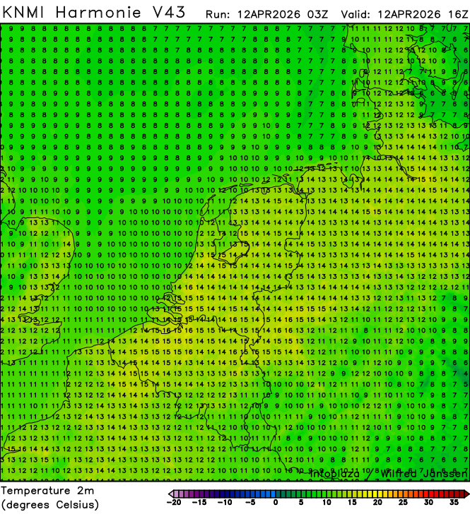
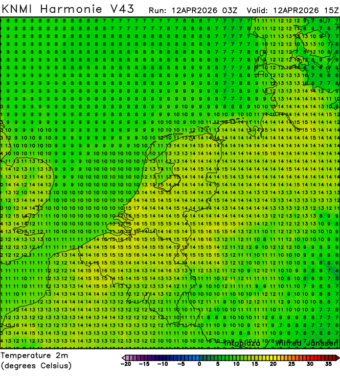
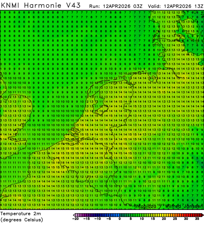
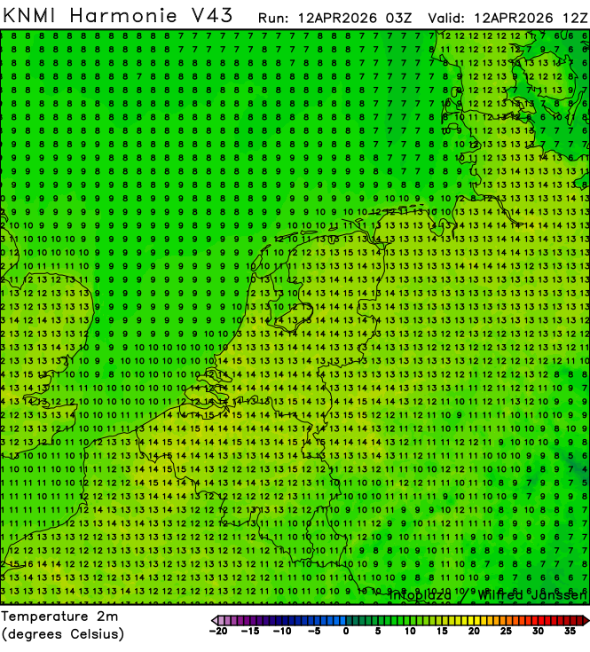
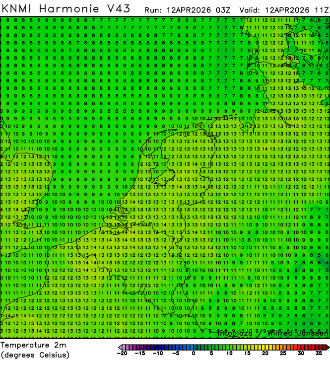
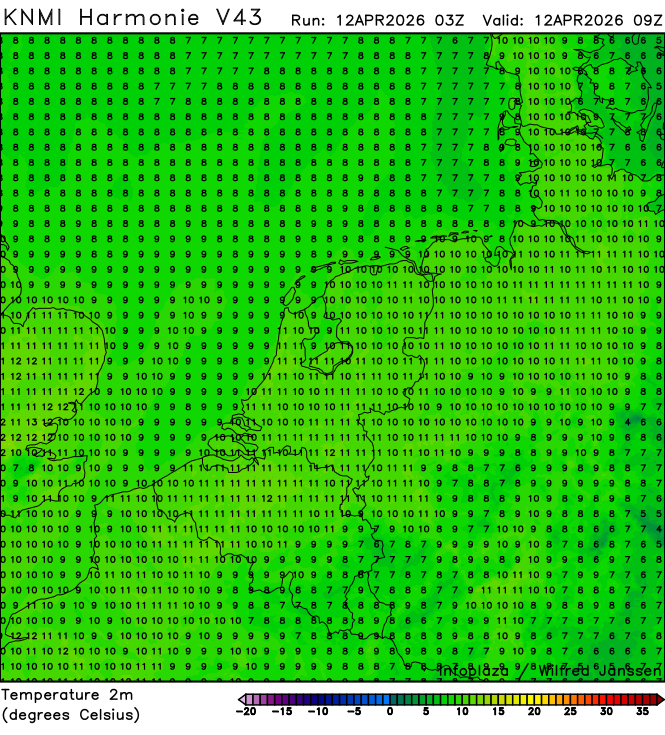
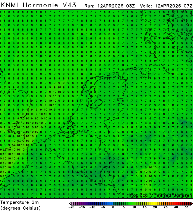
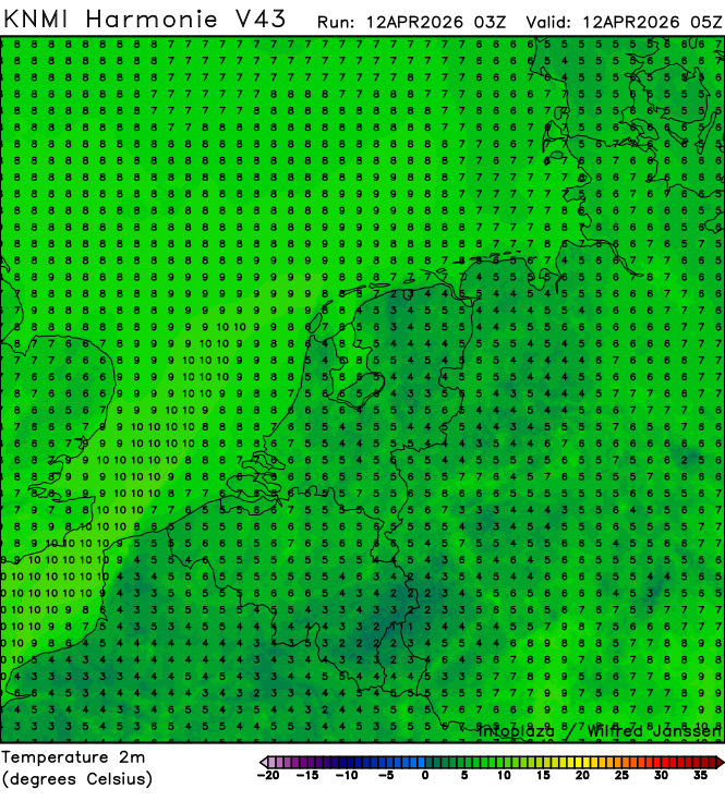
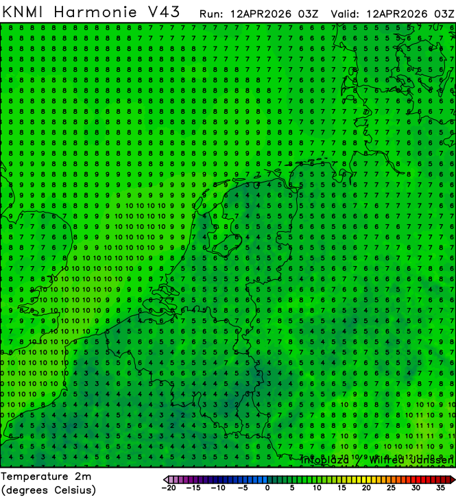
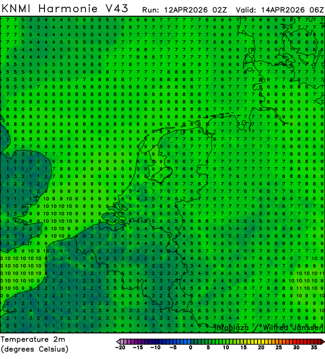
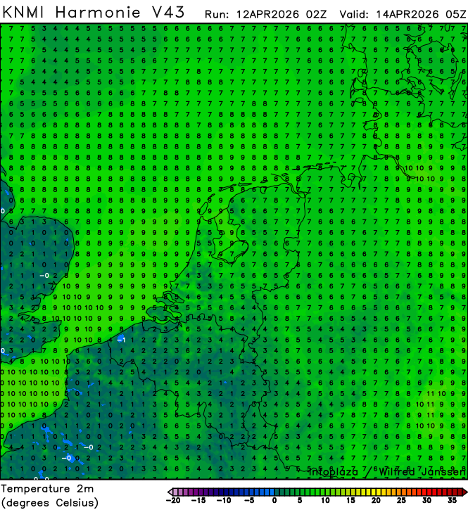
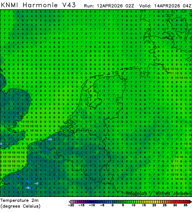
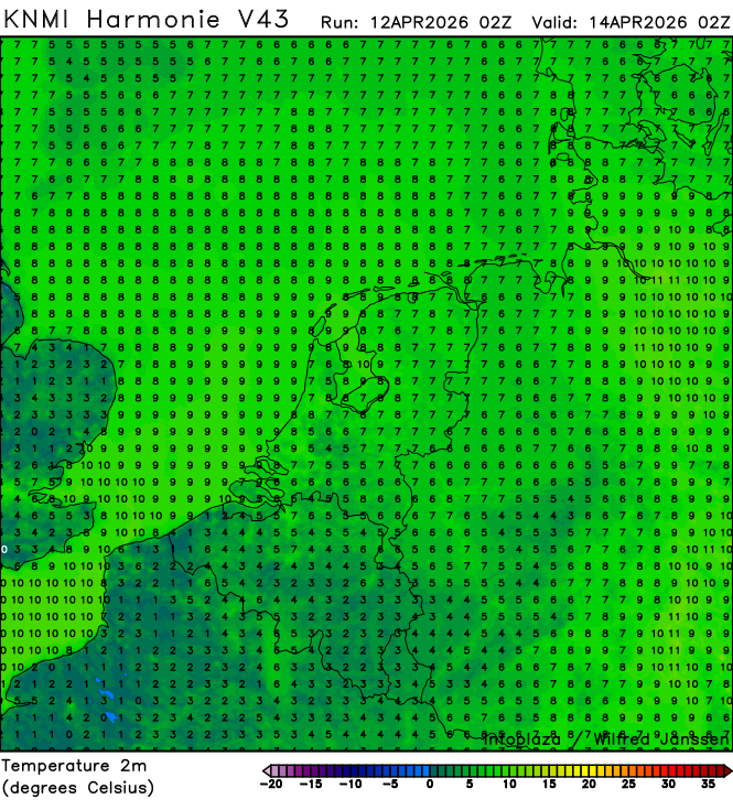
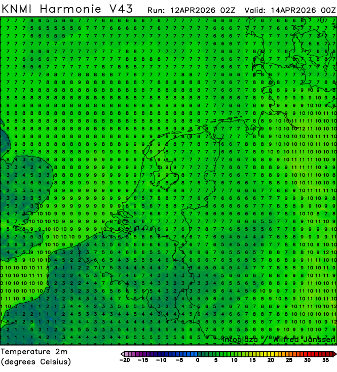
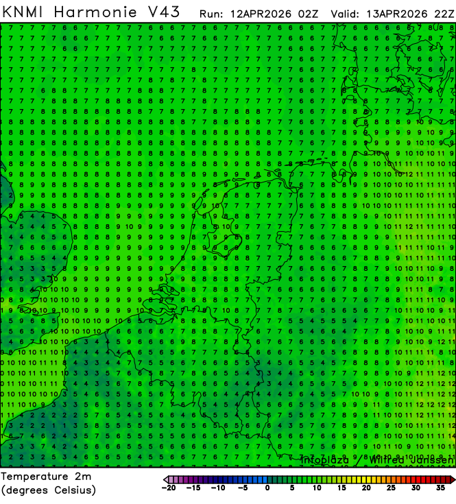
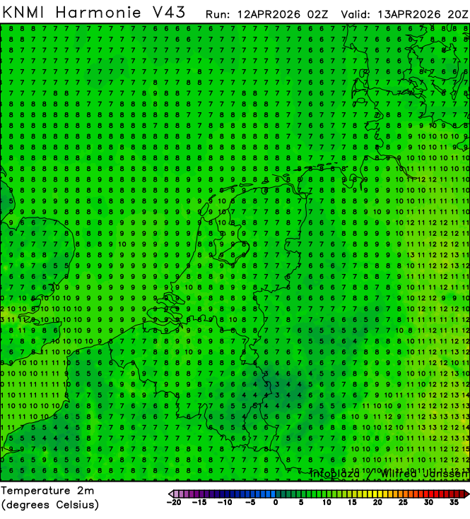
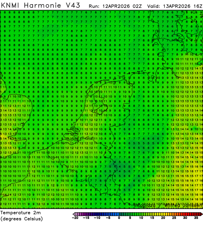
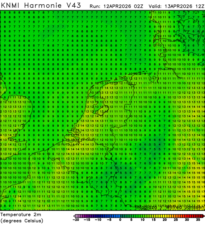
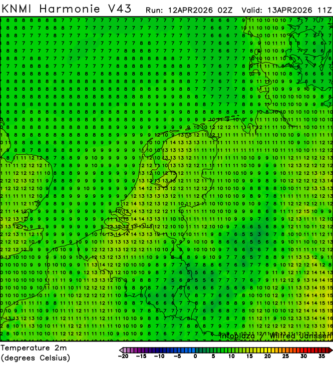
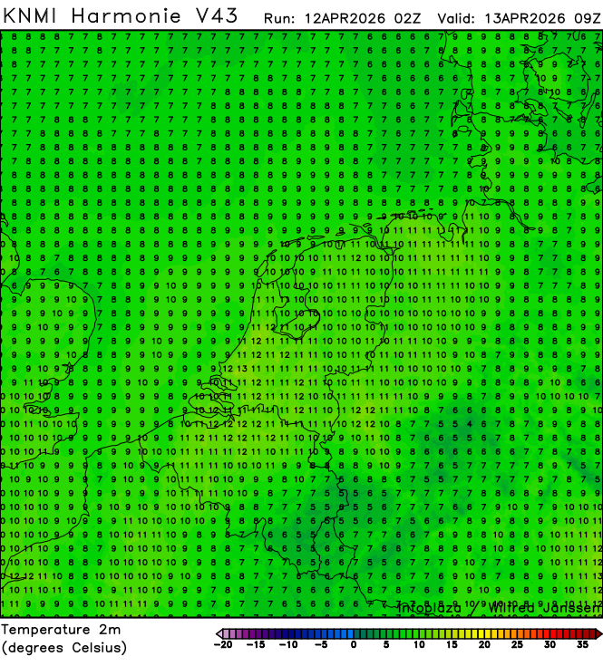
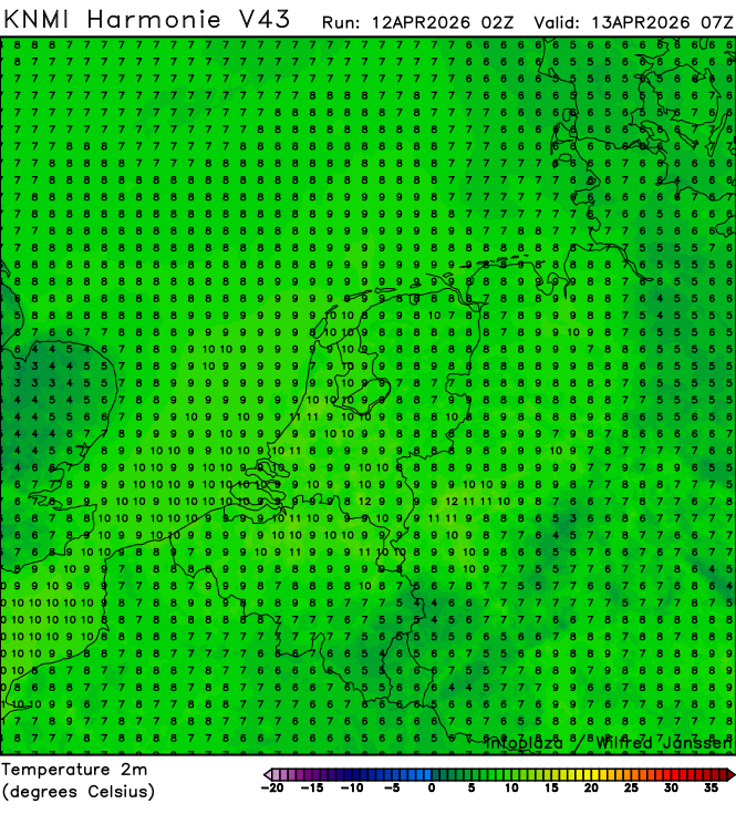
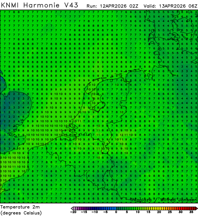
h43_temperature2m_02300.png
2026-04-12 05:40
292K
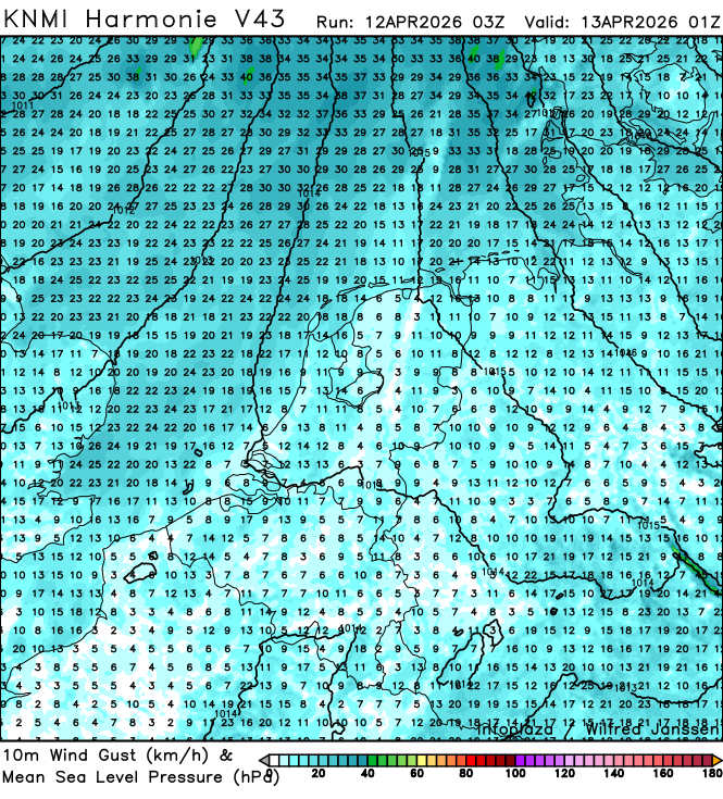
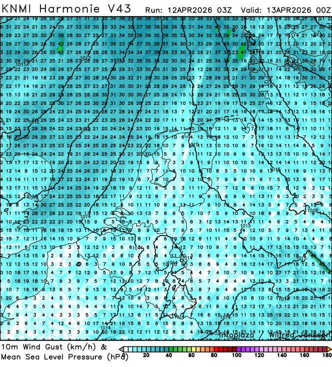
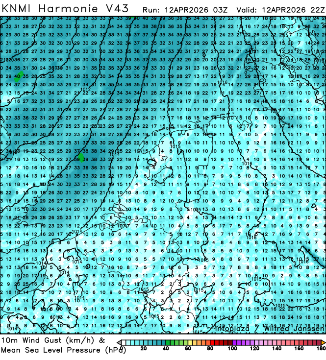
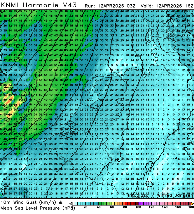
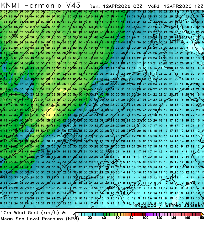
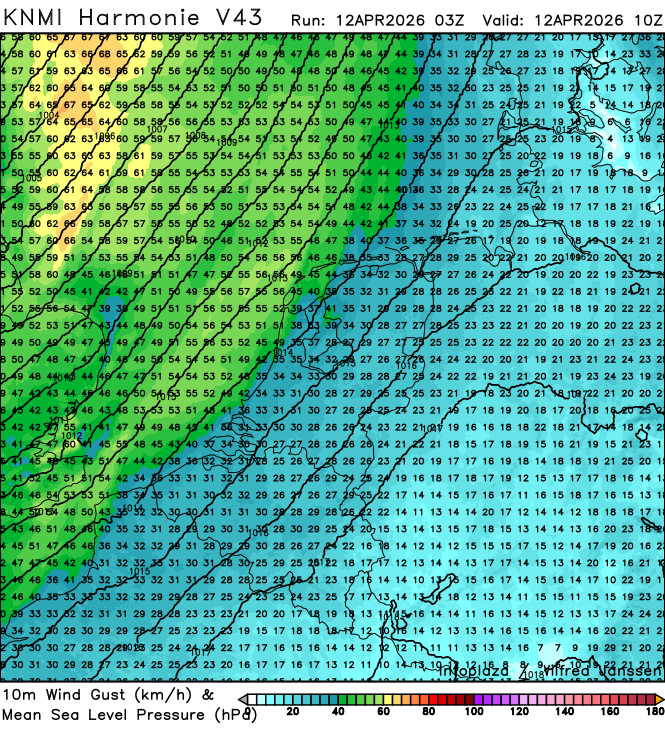
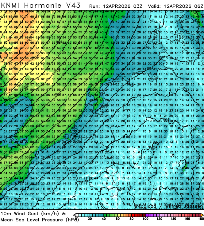
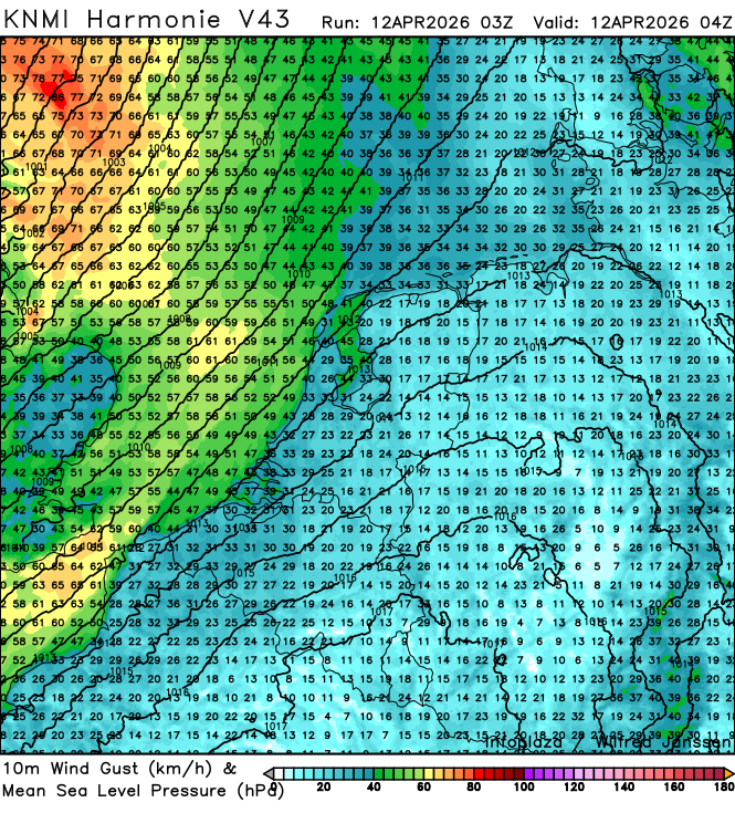
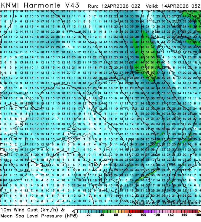
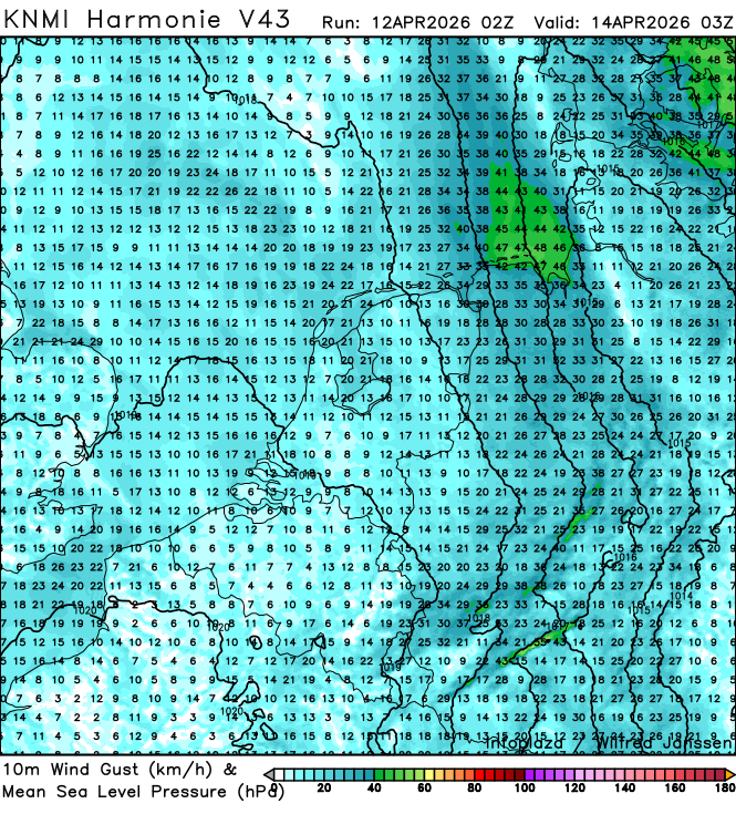
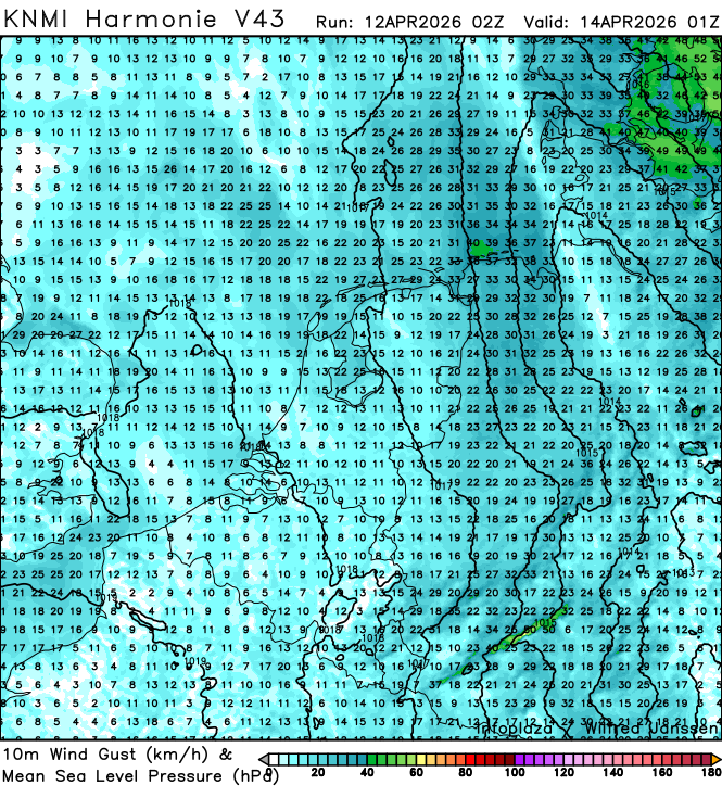
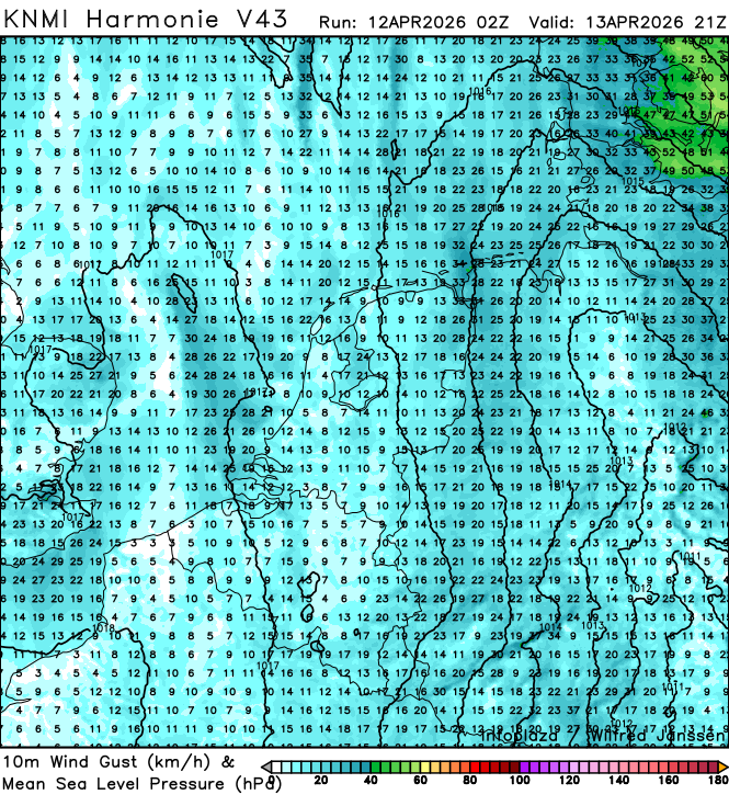
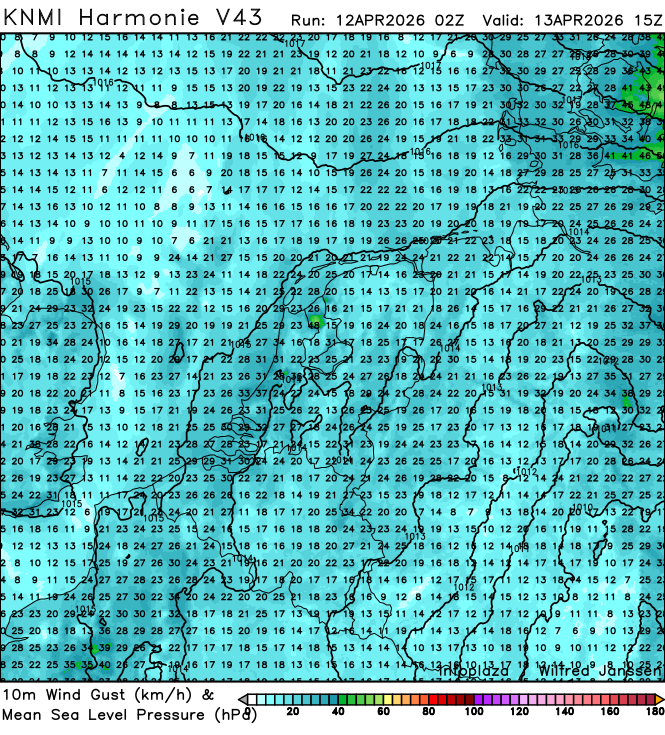
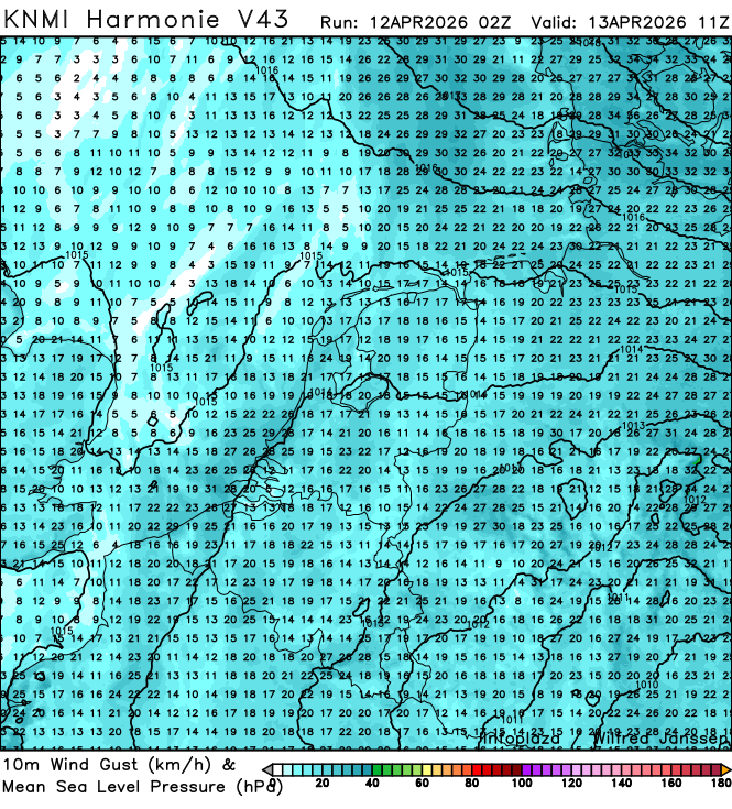
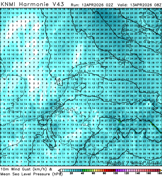
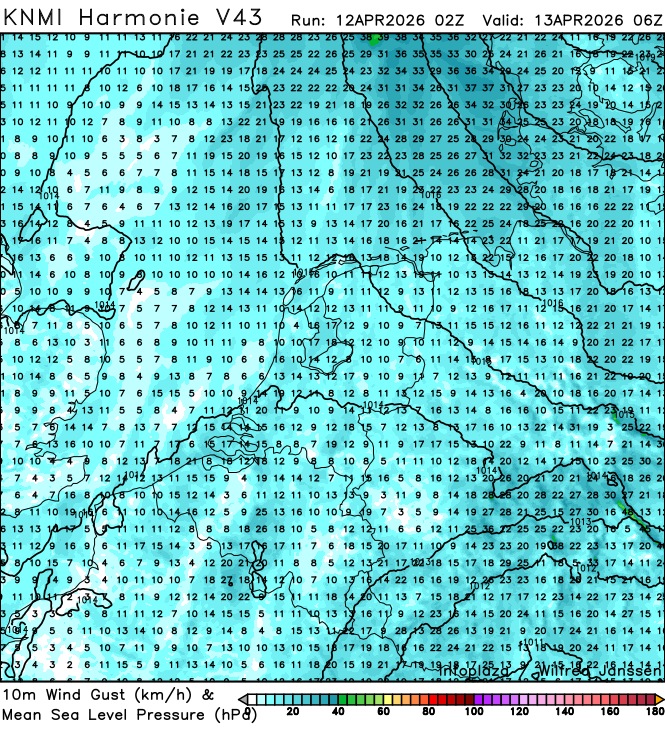
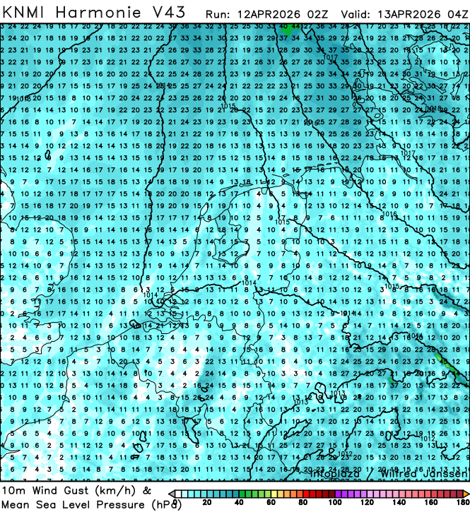
h43_windgust10m_02200.png
2026-04-12 05:40
456K
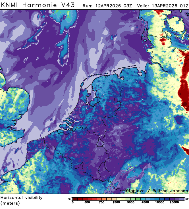
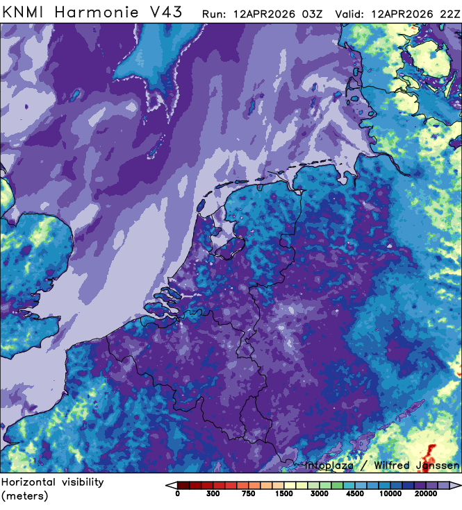
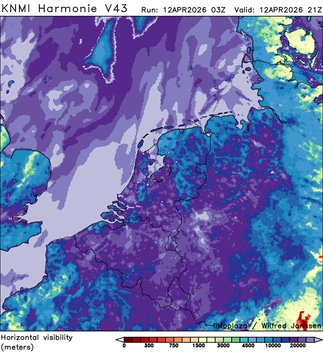
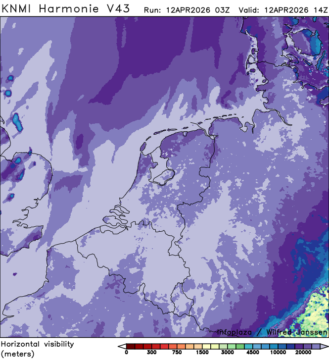
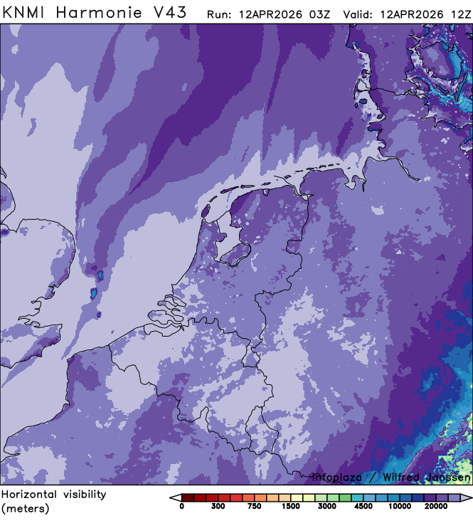
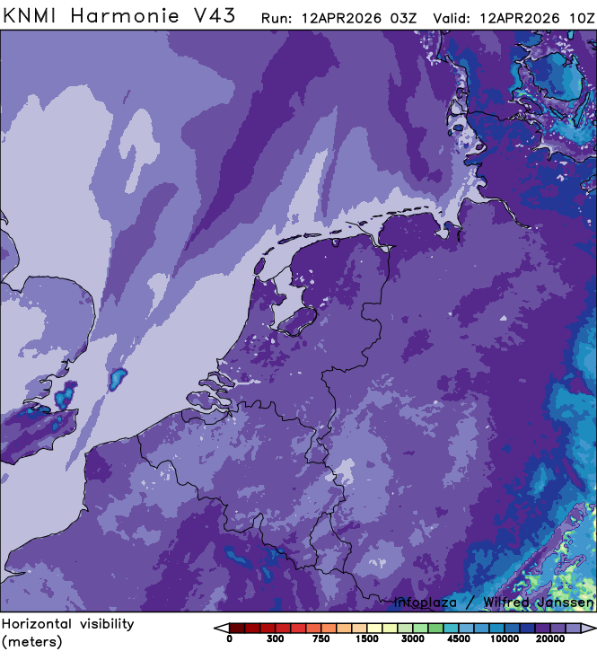
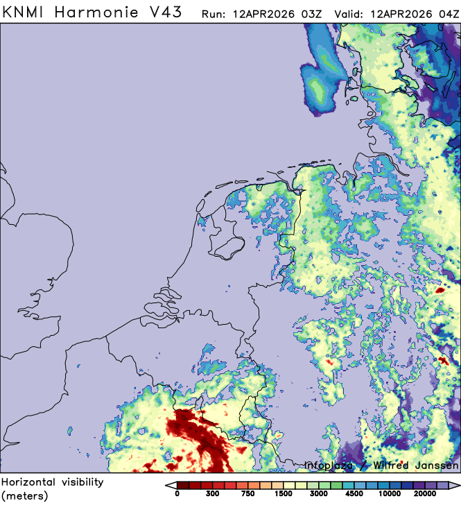
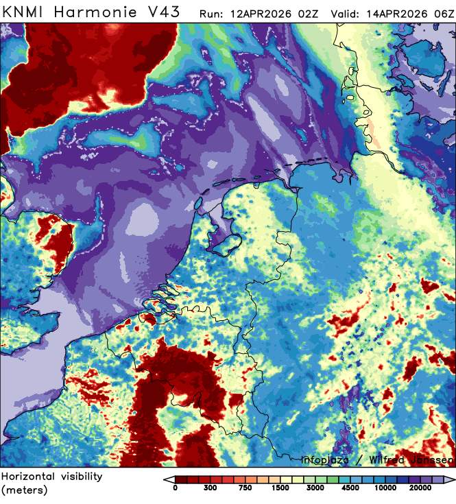
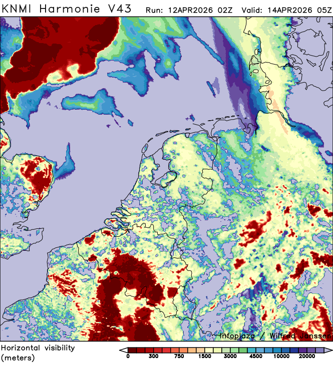
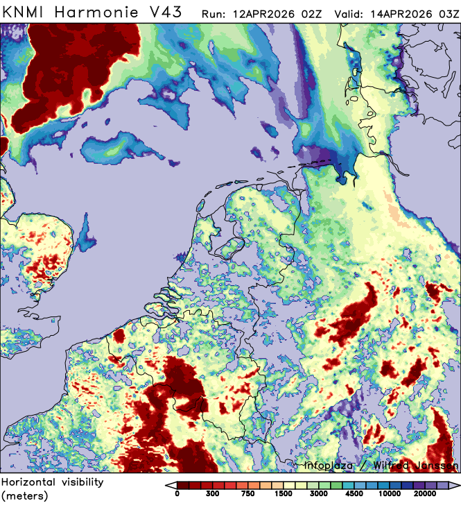
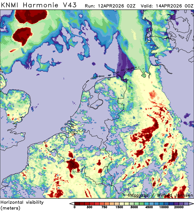
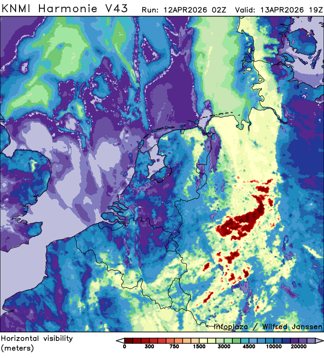
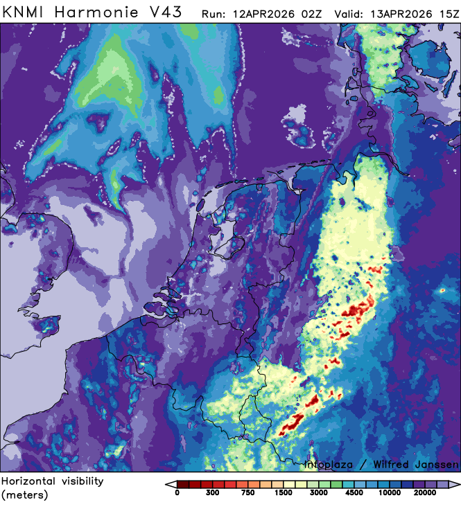
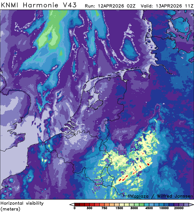
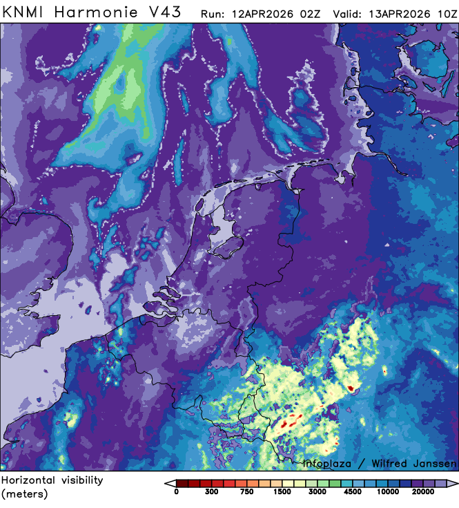
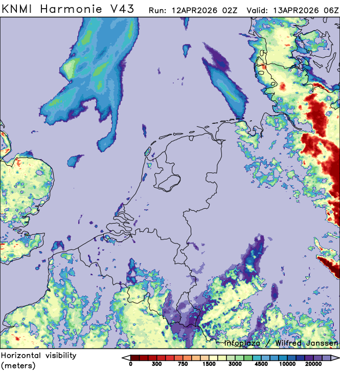
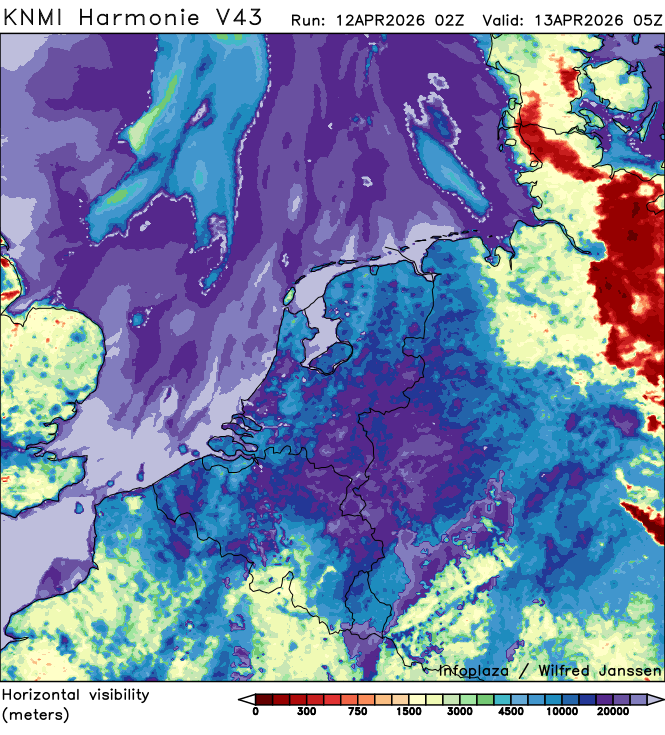
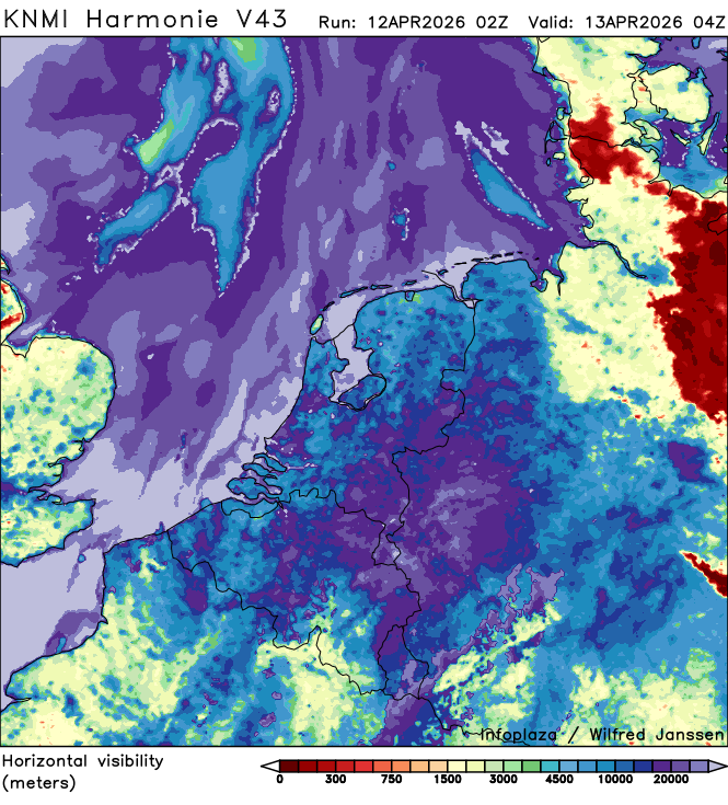
h43_visibility_02200.png
2026-04-12 05:40
213K
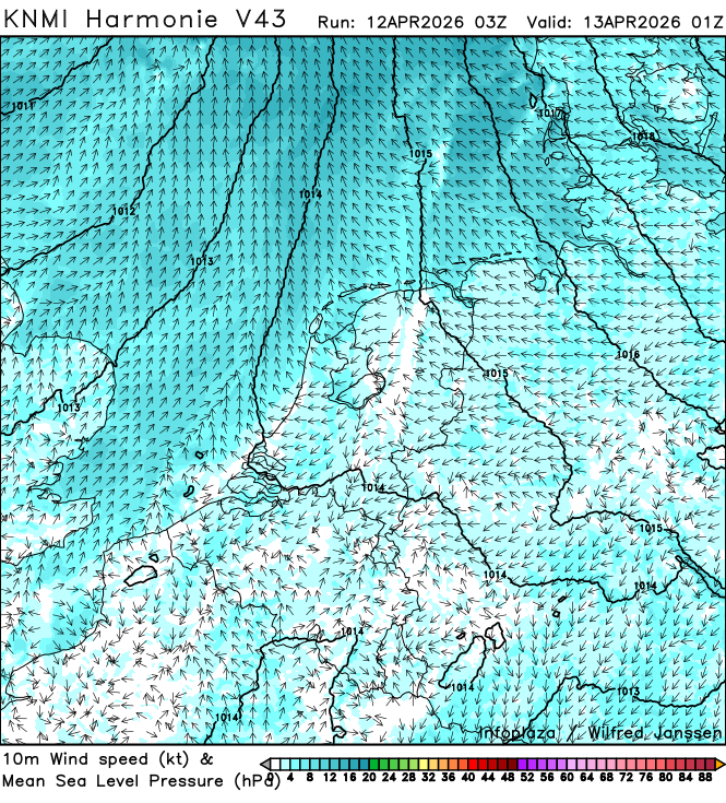
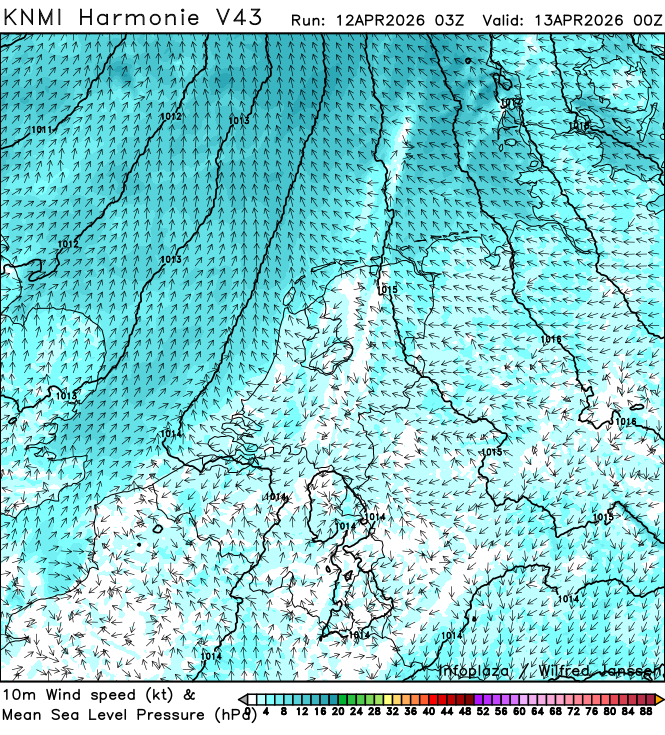
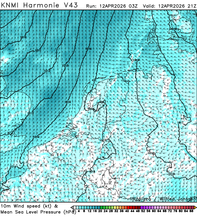
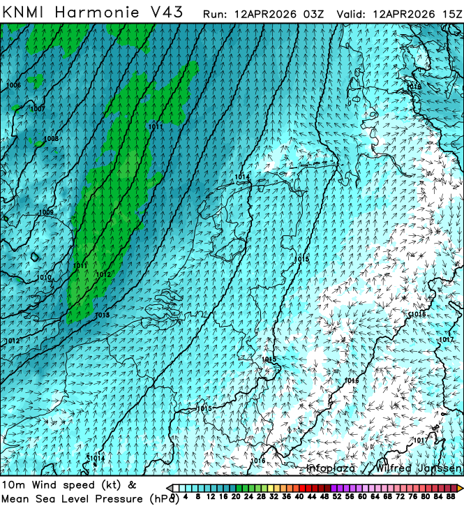
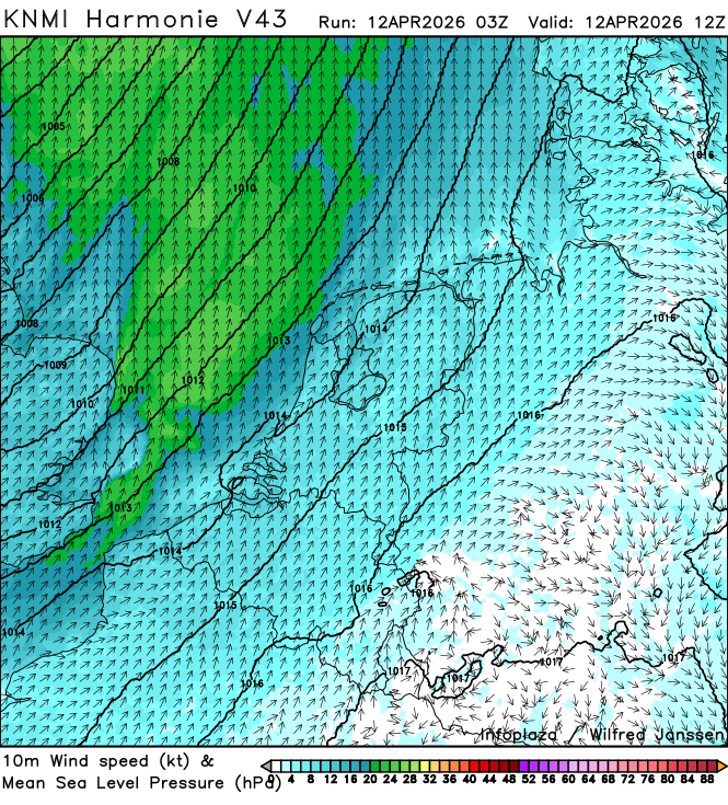
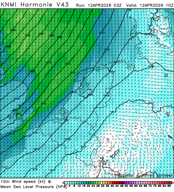
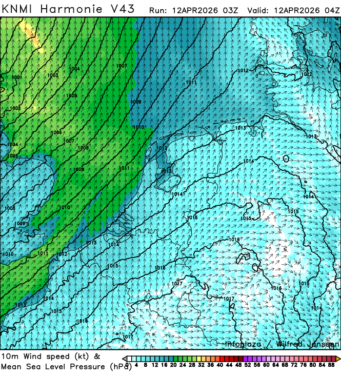
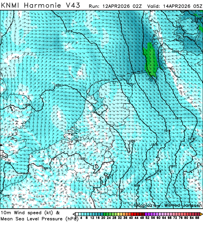
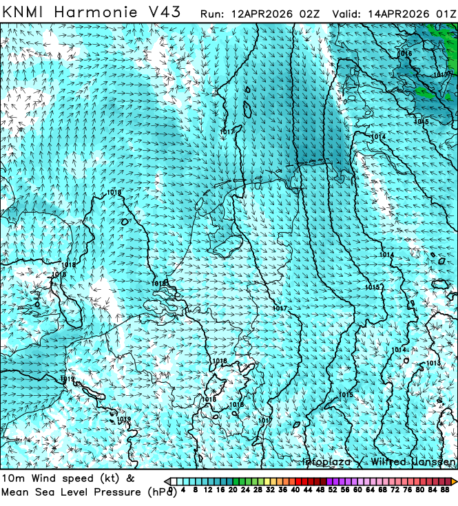
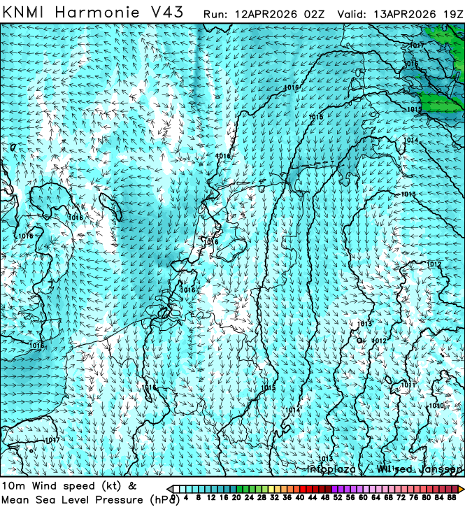
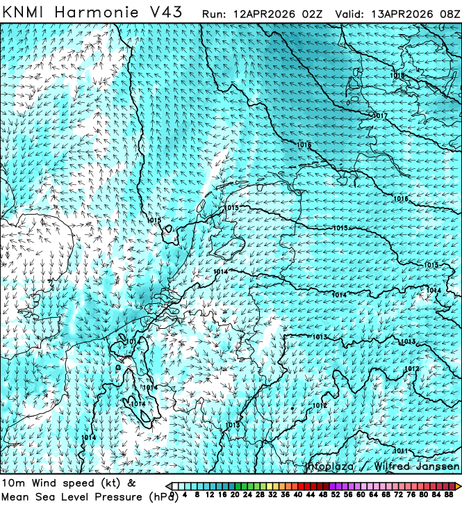
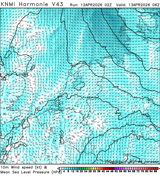
h43_wind10m_kt_02200.png
2026-04-12 05:40
575K
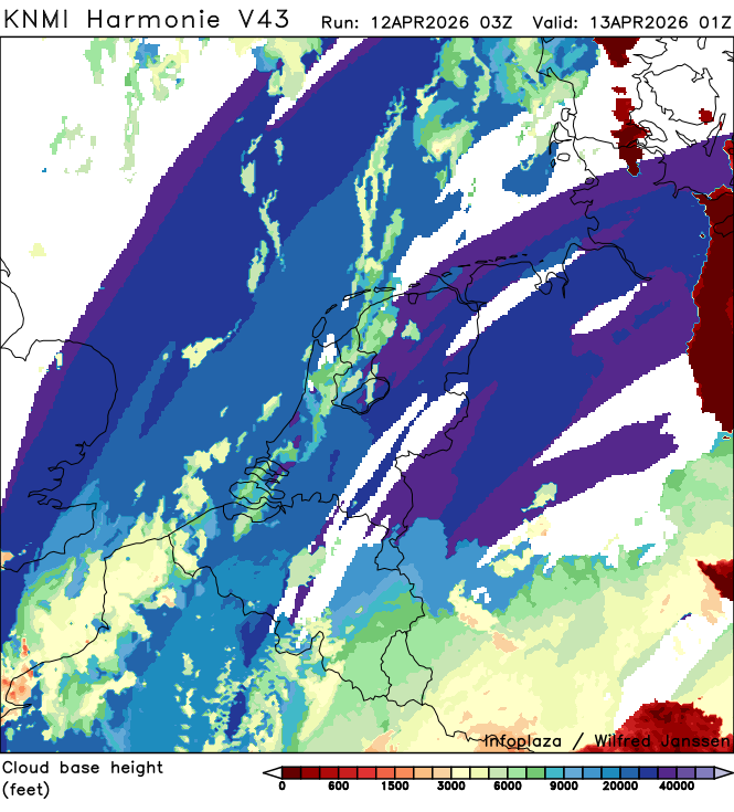
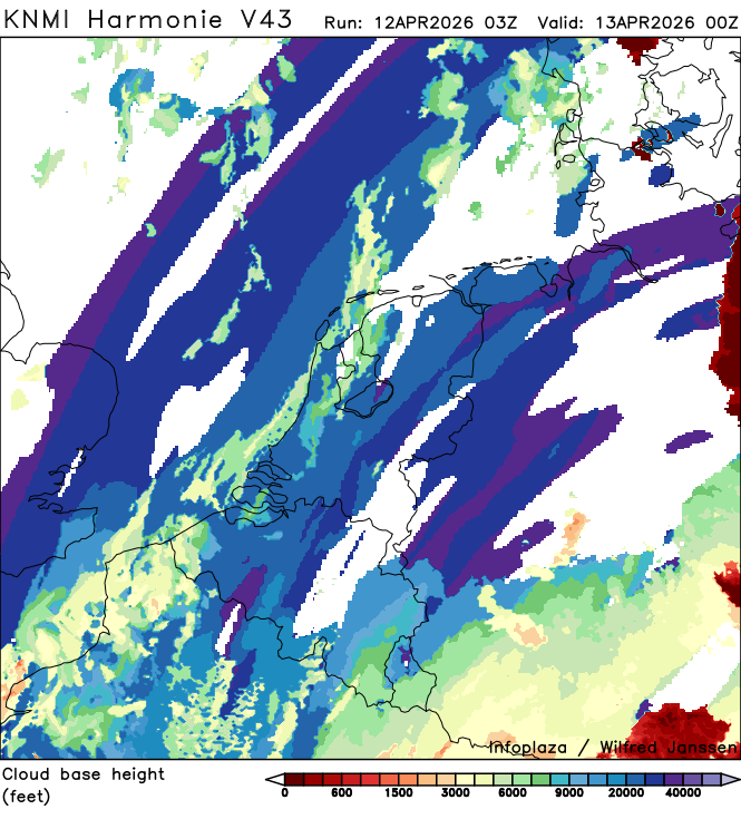
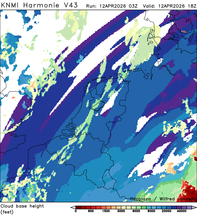
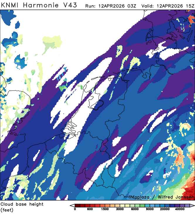
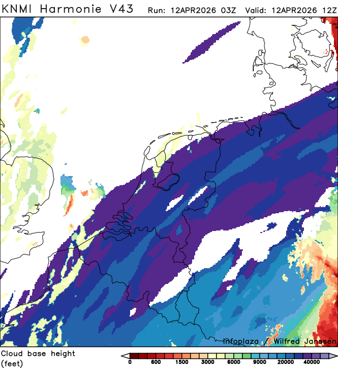
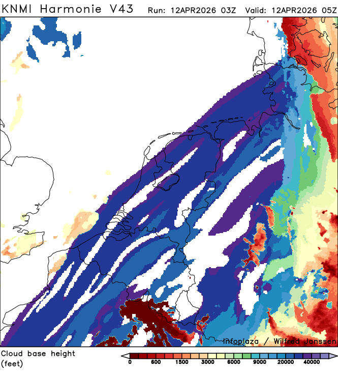
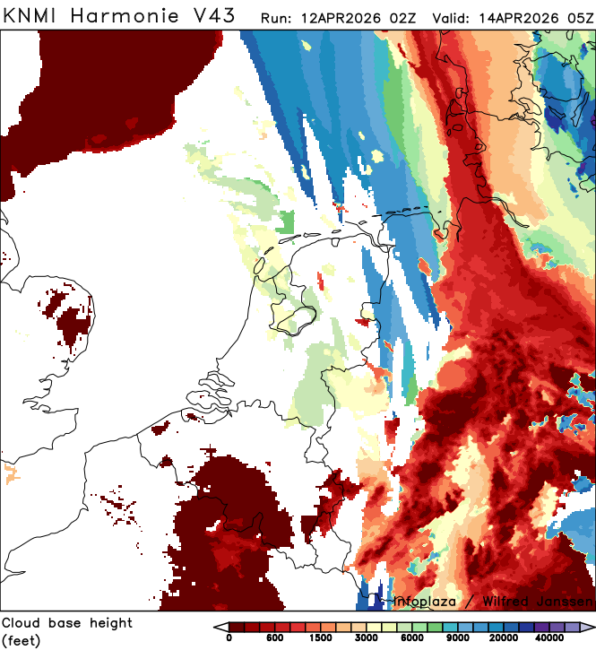
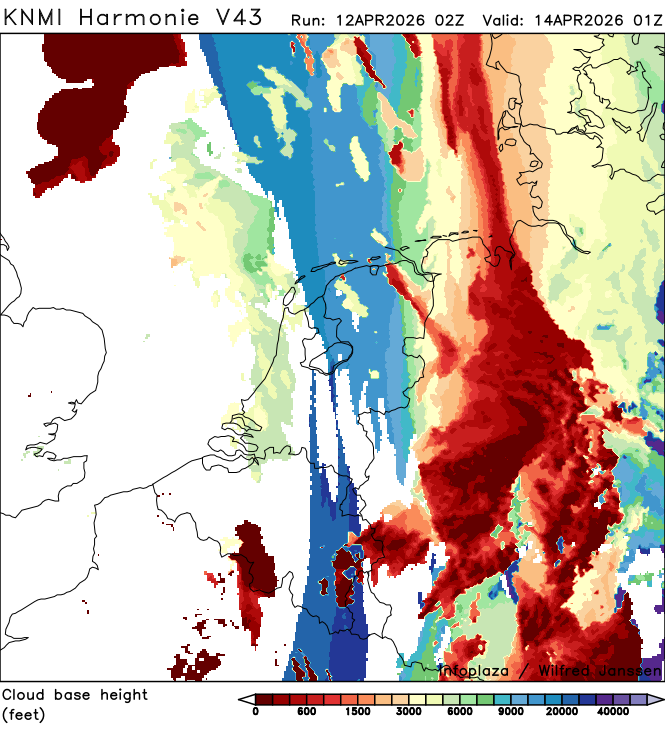
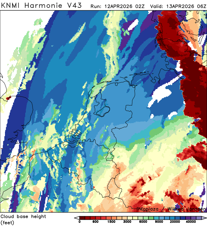
h43_cloudbase_02200.png
2026-04-12 05:40
148K
h43_pcptype_02200.png
2026-04-12 05:40
85K
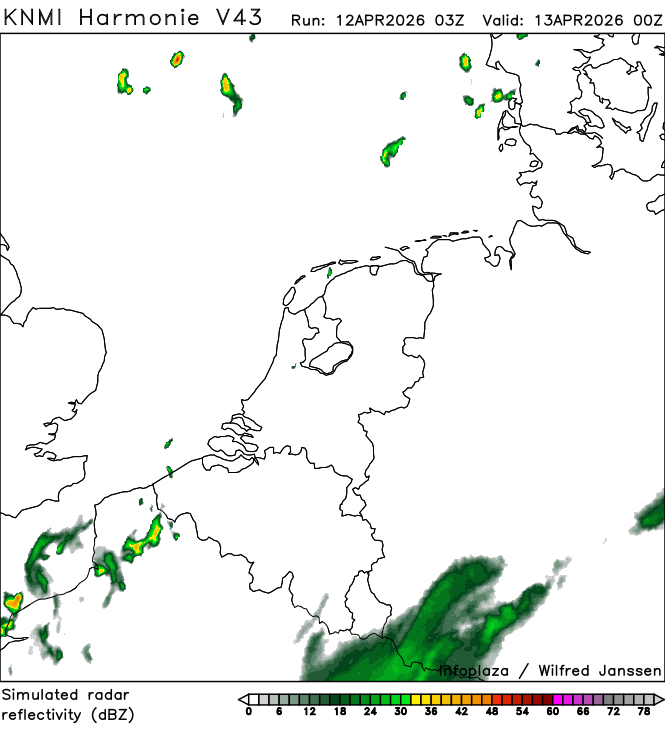
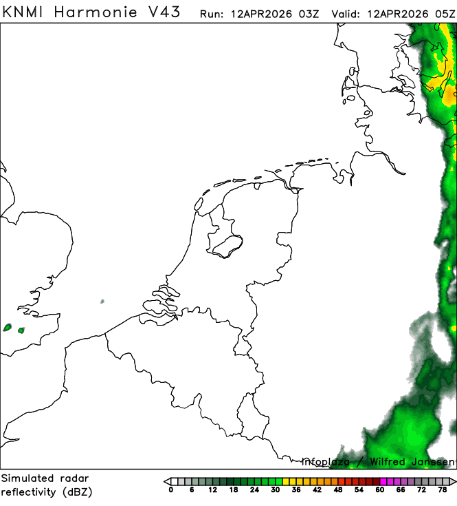
h43_simradar_02200.png
2026-04-12 05:40
101K
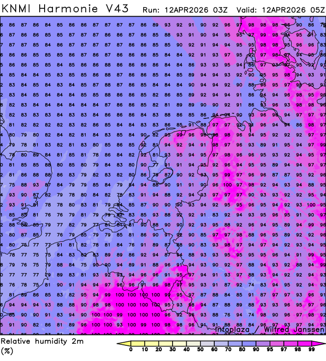
h43_humidity_02200.png
2026-04-12 05:40
352K
h43_temperature2m_02200.png
2026-04-12 05:40
294K
h43_dewpoint2m_02200.png
2026-04-12 05:40
309K
h43_windgust10m_02100.png
2026-04-12 05:40
459K
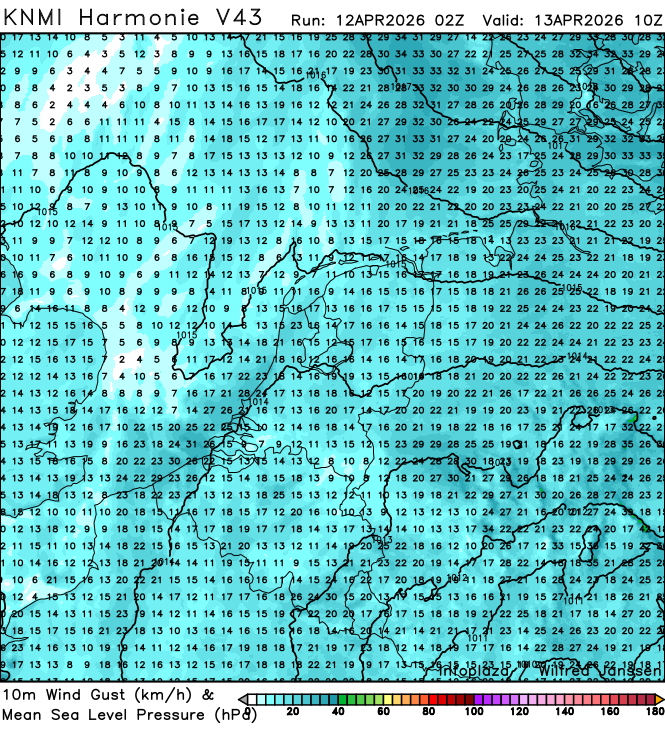
h43_visibility_02100.png
2026-04-12 05:40
204K
h43_wind10m_kt_02100.png
2026-04-12 05:40
577K
h43_cloudbase_02100.png
2026-04-12 05:40
148K
h43_pcptype_02100.png
2026-04-12 05:40
85K
h43_simradar_02100.png
2026-04-12 05:40
98K
h43_humidity_02100.png
2026-04-12 05:40
348K
h43_dewpoint2m_02100.png
2026-04-12 05:40
307K
h43_visibility_02000.png
2026-04-12 05:40
197K
h43_temperature2m_02100.png
2026-04-12 05:40
296K
h43_windgust10m_02000.png
2026-04-12 05:40
469K
h43_wind10m_kt_02000.png
2026-04-12 05:40
585K
h43_cloudbase_02000.png
2026-04-12 05:40
147K
h43_pcptype_02000.png
2026-04-12 05:40
85K
h43_simradar_02000.png
2026-04-12 05:40
96K
h43_humidity_02000.png
2026-04-12 05:40
346K
h43_dewpoint2m_02000.png
2026-04-12 05:40
306K
h43_temperature2m_02000.png
2026-04-12 05:40
296K
h43_windgust10m_01900.png
2026-04-12 05:40
468K
h43_visibility_01900.png
2026-04-12 05:40
189K
h43_wind10m_kt_01900.png
2026-04-12 05:39
584K
h43_cloudbase_01900.png
2026-04-12 05:39
146K
h43_simradar_01900.png
2026-04-12 05:39
94K
h43_pcptype_01900.png
2026-04-12 05:39
84K
h43_humidity_01900.png
2026-04-12 05:39
345K
h43_temperature2m_01900.png
2026-04-12 05:39
297K
h43_dewpoint2m_01900.png
2026-04-12 05:39
306K
h43_windgust10m_01800.png
2026-04-12 05:39
452K
h43_wind10m_kt_01800.png
2026-04-12 05:39
574K
h43_visibility_01800.png
2026-04-12 05:39
181K
h43_cloudbase_01800.png
2026-04-12 05:39
147K
h43_simradar_01800.png
2026-04-12 05:39
91K
h43_pcptype_01800.png
2026-04-12 05:39
85K
h43_humidity_01800.png
2026-04-12 05:39
340K
h43_temperature2m_01800.png
2026-04-12 05:39
297K
h43_dewpoint2m_01800.png
2026-04-12 05:39
305K
h43_windgust10m_01700.png
2026-04-12 05:39
460K
h43_visibility_01700.png
2026-04-12 05:39
171K
h43_wind10m_kt_01700.png
2026-04-12 05:39
576K
h43_cloudbase_01700.png
2026-04-12 05:39
141K
h43_pcptype_01700.png
2026-04-12 05:39
85K
h43_simradar_01700.png
2026-04-12 05:39
92K
h43_humidity_01700.png
2026-04-12 05:39
338K
h43_dewpoint2m_01700.png
2026-04-12 05:39
305K
h43_windgust10m_01600.png
2026-04-12 05:39
467K
h43_visibility_01600.png
2026-04-12 05:39
160K
h43_temperature2m_01700.png
2026-04-12 05:39
297K
h43_wind10m_kt_01600.png
2026-04-12 05:39
579K
h43_cloudbase_01600.png
2026-04-12 05:39
141K
h43_pcptype_01600.png
2026-04-12 05:39
84K
h43_simradar_01600.png
2026-04-12 05:39
92K
h43_humidity_01600.png
2026-04-12 05:39
338K
h43_dewpoint2m_01600.png
2026-04-12 05:39
309K
h43_visibility_01500.png
2026-04-12 05:39
153K
h43_temperature2m_01600.png
2026-04-12 05:39
302K
h43_windgust10m_01500.png
2026-04-12 05:39
476K
h43_wind10m_kt_01500.png
2026-04-12 05:39
575K
h43_cloudbase_01500.png
2026-04-12 05:39
140K
h43_simradar_01500.png
2026-04-12 05:39
93K
h43_pcptype_01500.png
2026-04-12 05:39
84K
h43_temperature2m_01500.png
2026-04-12 05:39
307K
h43_humidity_01500.png
2026-04-12 05:39
337K
h43_dewpoint2m_01500.png
2026-04-12 05:39
316K
h43_windgust10m_01400.png
2026-04-12 05:39
485K
h43_wind10m_kt_01400.png
2026-04-12 05:39
578K
h43_visibility_01400.png
2026-04-12 05:39
148K
h43_cloudbase_01400.png
2026-04-12 05:39
137K
h43_simradar_01400.png
2026-04-12 05:39
92K
h43_pcptype_01400.png
2026-04-12 05:39
83K
h43_humidity_01400.png
2026-04-12 05:39
341K
h43_dewpoint2m_01400.png
2026-04-12 05:39
320K
h43_windgust10m_01300.png
2026-04-12 05:39
485K
h43_visibility_01300.png
2026-04-12 05:39
97K
h43_temperature2m_01400.png
2026-04-12 05:39
314K
h43_wind10m_kt_01300.png
2026-04-12 05:39
570K
h43_cloudbase_01300.png
2026-04-12 05:39
136K
h43_simradar_01300.png
2026-04-12 05:39
94K
h43_pcptype_01300.png
2026-04-12 05:39
83K
h43_humidity_01300.png
2026-04-12 05:39
331K
h43_dewpoint2m_01300.png
2026-04-12 05:39
315K
h43_windgust10m_01200.png
2026-04-12 05:39
490K
h43_visibility_01200.png
2026-04-12 05:39
129K
h43_temperature2m_01300.png
2026-04-12 05:39
318K
h43_wind10m_kt_01200.png
2026-04-12 05:39
569K
h43_cloudbase_01200.png
2026-04-12 05:39
133K
h43_simradar_01200.png
2026-04-12 05:39
90K
h43_pcptype_01200.png
2026-04-12 05:39
82K
h43_temperature2m_01200.png
2026-04-12 05:39
321K
h43_humidity_01200.png
2026-04-12 05:39
325K
h43_dewpoint2m_01200.png
2026-04-12 05:39
313K
h43_windgust10m_01100.png
2026-04-12 05:39
496K
h43_visibility_01100.png
2026-04-12 05:39
126K
h43_wind10m_kt_01100.png
2026-04-12 05:39
572K
h43_cloudbase_01100.png
2026-04-12 05:39
124K
h43_simradar_01100.png
2026-04-12 05:39
87K
h43_pcptype_01100.png
2026-04-12 05:39
81K
h43_humidity_01100.png
2026-04-12 05:39
327K
h43_visibility_01000.png
2026-04-12 05:39
127K
h43_temperature2m_01100.png
2026-04-12 05:39
320K
h43_dewpoint2m_01100.png
2026-04-12 05:39
316K
h43_windgust10m_01000.png
2026-04-12 05:39
501K
h43_wind10m_kt_01000.png
2026-04-12 05:39
573K
h43_cloudbase_01000.png
2026-04-12 05:39
120K
h43_pcptype_01000.png
2026-04-12 05:39
80K
h43_simradar_01000.png
2026-04-12 05:39
84K
h43_humidity_01000.png
2026-04-12 05:39
326K
h43_dewpoint2m_01000.png
2026-04-12 05:39
315K
h43_temperature2m_01000.png
2026-04-12 05:39
318K
h43_windgust10m_00900.png
2026-04-12 05:39
506K
h43_wind10m_kt_00900.png
2026-04-12 05:39
576K
h43_visibility_00900.png
2026-04-12 05:39
126K
h43_cloudbase_00900.png
2026-04-12 05:38
118K
h43_simradar_00900.png
2026-04-12 05:38
84K
h43_pcptype_00900.png
2026-04-12 05:38
80K
h43_temperature2m_00900.png
2026-04-12 05:38
315K
h43_humidity_00900.png
2026-04-12 05:38
326K
h43_dewpoint2m_00900.png
2026-04-12 05:38
311K
h43_windgust10m_00800.png
2026-04-12 05:38
511K
h43_wind10m_kt_00800.png
2026-04-12 05:38
579K
h43_visibility_00800.png
2026-04-12 05:38
93K
h43_cloudbase_00800.png
2026-04-12 05:38
113K
h43_pcptype_00800.png
2026-04-12 05:38
80K
h43_simradar_00800.png
2026-04-12 05:38
85K
h43_humidity_00800.png
2026-04-12 05:38
325K
h43_temperature2m_00800.png
2026-04-12 05:38
311K
h43_dewpoint2m_00800.png
2026-04-12 05:38
309K
h43_windgust10m_00700.png
2026-04-12 05:38
512K
h43_wind10m_kt_00700.png
2026-04-12 05:38
580K
h43_visibility_00700.png
2026-04-12 05:38
132K
h43_cloudbase_00700.png
2026-04-12 05:38
112K
h43_pcptype_00700.png
2026-04-12 05:38
81K
h43_simradar_00700.png
2026-04-12 05:38
85K
h43_humidity_00700.png
2026-04-12 05:38
322K
h43_dewpoint2m_00700.png
2026-04-12 05:38
307K
h43_windgust10m_00600.png
2026-04-12 05:38
528K
h43_visibility_00600.png
2026-04-12 05:38
136K
h43_temperature2m_00700.png
2026-04-12 05:38
300K
h43_wind10m_kt_00600.png
2026-04-12 05:38
590K
h43_cloudbase_00600.png
2026-04-12 05:38
114K
h43_pcptype_00600.png
2026-04-12 05:38
81K
h43_simradar_00600.png
2026-04-12 05:38
85K
h43_humidity_00600.png
2026-04-12 05:38
318K
h43_temperature2m_00600.png
2026-04-12 05:38
286K
h43_dewpoint2m_00600.png
2026-04-12 05:38
305K
h43_windgust10m_00500.png
2026-04-12 05:38
532K
h43_wind10m_kt_00500.png
2026-04-12 05:38
590K
h43_visibility_00500.png
2026-04-12 05:38
147K
h43_cloudbase_00500.png
2026-04-12 05:38
120K
h43_pcptype_00500.png
2026-04-12 05:38
83K
h43_simradar_00500.png
2026-04-12 05:38
85K
h43_humidity_00500.png
2026-04-12 05:38
318K
h43_dewpoint2m_00500.png
2026-04-12 05:38
299K
h43_visibility_00400.png
2026-04-12 05:38
123K
h43_temperature2m_00500.png
2026-04-12 05:38
272K
h43_windgust10m_00400.png
2026-04-12 05:38
538K
h43_wind10m_kt_00400.png
2026-04-12 05:38
595K
h43_cloudbase_00400.png
2026-04-12 05:38
120K
h43_pcptype_00400.png
2026-04-12 05:38
84K
h43_simradar_00400.png
2026-04-12 05:38
86K
h43_humidity_00400.png
2026-04-12 05:38
325K
h43_dewpoint2m_00400.png
2026-04-12 05:38
303K
h43_windgust10m_00300.png
2026-04-12 05:38
549K
h43_visibility_00300.png
2026-04-12 05:38
188K
h43_temperature2m_00400.png
2026-04-12 05:38
262K
h43_wind10m_kt_00300.png
2026-04-12 05:38
604K
h43_cloudbase_00300.png
2026-04-12 05:38
125K
h43_pcptype_00300.png
2026-04-12 05:38
85K
h43_simradar_00300.png
2026-04-12 05:38
92K
h43_humidity_00300.png
2026-04-12 05:38
338K
h43_temperature2m_00300.png
2026-04-12 05:38
275K
h43_dewpoint2m_00300.png
2026-04-12 05:38
302K
h43_windgust10m_00200.png
2026-04-12 05:38
549K
h43_wind10m_kt_00200.png
2026-04-12 05:38
606K
h43_visibility_00200.png
2026-04-12 05:38
195K
h43_cloudbase_00200.png
2026-04-12 05:38
130K
h43_pcptype_00200.png
2026-04-12 05:38
86K
h43_simradar_00200.png
2026-04-12 05:38
97K
h43_humidity_00200.png
2026-04-12 05:38
341K
h43_visibility_00100.png
2026-04-12 05:38
200K
h43_temperature2m_00200.png
2026-04-12 05:38
280K
h43_dewpoint2m_00200.png
2026-04-12 05:38
304K
h43_windgust10m_00100.png
2026-04-12 05:38
554K
h43_wind10m_kt_00100.png
2026-04-12 05:38
609K
h43_pcptype_00100.png
2026-04-12 05:38
78K
h43_cloudbase_00100.png
2026-04-12 05:38
129K
h43_simradar_00100.png
2026-04-12 05:38
104K
h43_humidity_00100.png
2026-04-12 05:38
342K
h43_dewpoint2m_00100.png
2026-04-12 05:38
305K
h43_temperature2m_00100.png
2026-04-12 05:38
279K
h43_windgust10m_00000.png
2026-04-12 05:38
549K
h43_wind10m_kt_00000.png
2026-04-12 05:38
617K
h43_visibility_00000.png
2026-04-12 05:38
211K
h43_cloudbase_00000.png
2026-04-12 05:38
131K
h43_pcptype_00000.png
2026-04-12 05:38
78K
h43_simradar_00000.png
2026-04-12 05:38
112K
h43_humidity_00000.png
2026-04-12 05:38
342K
h43_dewpoint2m_00000.png
2026-04-12 05:38
309K
h43_temperature2m_00000.png
2026-04-12 05:38
280K
h43_visibility_05300.png
2026-04-12 04:40
242K
h43_windgust10m_05300.png
2026-04-12 04:40
475K
h43_wind10m_kt_05300.png
2026-04-12 04:40
595K
h43_cloudbase_05300.png
2026-04-12 04:40
130K
h43_pcptype_05300.png
2026-04-12 04:40
90K
h43_simradar_05300.png
2026-04-12 04:40
115K
h43_humidity_05300.png
2026-04-12 04:40
348K
h43_dewpoint2m_05300.png
2026-04-12 04:40
298K
h43_visibility_05200.png
2026-04-12 04:40
276K
h43_temperature2m_05300.png
2026-04-12 04:40
273K
h43_windgust10m_05200.png
2026-04-12 04:40
476K
h43_wind10m_kt_05200.png
2026-04-12 04:40
599K
h43_cloudbase_05200.png
2026-04-12 04:40
134K
h43_pcptype_05200.png
2026-04-12 04:40
91K
h43_simradar_05200.png
2026-04-12 04:40
117K
h43_humidity_05200.png
2026-04-12 04:40
362K
h43_dewpoint2m_05200.png
2026-04-12 04:40
301K
h43_visibility_05100.png
2026-04-12 04:40
276K
h43_temperature2m_05200.png
2026-04-12 04:40
277K
h43_windgust10m_05100.png
2026-04-12 04:40
474K
h43_wind10m_kt_05100.png
2026-04-12 04:40
597K
h43_cloudbase_05100.png
2026-04-12 04:40
136K
h43_pcptype_05100.png
2026-04-12 04:40
91K
h43_simradar_05100.png
2026-04-12 04:40
120K
h43_temperature2m_05100.png
2026-04-12 04:40
276K
h43_humidity_05100.png
2026-04-12 04:40
364K
h43_dewpoint2m_05100.png
2026-04-12 04:40
307K
h43_windgust10m_05000.png
2026-04-12 04:40
479K
h43_visibility_05000.png
2026-04-12 04:40
278K
h43_wind10m_kt_05000.png
2026-04-12 04:40
600K
h43_cloudbase_05000.png
2026-04-12 04:40
140K
h43_pcptype_05000.png
2026-04-12 04:40
91K
h43_simradar_05000.png
2026-04-12 04:40
124K
h43_humidity_05000.png
2026-04-12 04:40
363K
h43_temperature2m_05000.png
2026-04-12 04:40
276K
h43_dewpoint2m_05000.png
2026-04-12 04:40
306K
h43_windgust10m_04900.png
2026-04-12 04:40
477K
h43_visibility_04900.png
2026-04-12 04:40
274K
h43_wind10m_kt_04900.png
2026-04-12 04:40
599K
h43_cloudbase_04900.png
2026-04-12 04:40
146K
h43_pcptype_04900.png
2026-04-12 04:40
93K
h43_simradar_04900.png
2026-04-12 04:40
125K
h43_humidity_04900.png
2026-04-12 04:40
362K
h43_dewpoint2m_04900.png
2026-04-12 04:40
307K
h43_visibility_04800.png
2026-04-12 04:40
272K
h43_temperature2m_04900.png
2026-04-12 04:40
277K
h43_windgust10m_04800.png
2026-04-12 04:40
477K
h43_wind10m_kt_04800.png
2026-04-12 04:40
597K
h43_cloudbase_04800.png
2026-04-12 04:40
154K
h43_pcptype_04800.png
2026-04-12 04:40
93K
h43_simradar_04800.png
2026-04-12 04:40
125K
h43_humidity_04800.png
2026-04-12 04:40
363K
h43_dewpoint2m_04800.png
2026-04-12 04:40
307K
h43_visibility_04700.png
2026-04-12 04:40
261K
h43_temperature2m_04800.png
2026-04-12 04:40
281K
h43_windgust10m_04700.png
2026-04-12 04:40
480K
h43_wind10m_kt_04700.png
2026-04-12 04:40
600K
h43_cloudbase_04700.png
2026-04-12 04:40
151K
h43_pcptype_04700.png
2026-04-12 04:40
92K
h43_simradar_04700.png
2026-04-12 04:40
127K
h43_humidity_04700.png
2026-04-12 04:40
364K
h43_dewpoint2m_04700.png
2026-04-12 04:40
305K
h43_visibility_04600.png
2026-04-12 04:39
257K
h43_temperature2m_04700.png
2026-04-12 04:39
280K
h43_windgust10m_04600.png
2026-04-12 04:39
474K
h43_wind10m_kt_04600.png
2026-04-12 04:39
598K
h43_cloudbase_04600.png
2026-04-12 04:39
153K
h43_pcptype_04600.png
2026-04-12 04:39
91K
h43_simradar_04600.png
2026-04-12 04:39
127K
h43_temperature2m_04600.png
2026-04-12 04:39
279K
h43_humidity_04600.png
2026-04-12 04:39
364K
h43_dewpoint2m_04600.png
2026-04-12 04:39
302K
h43_windgust10m_04500.png
2026-04-12 04:39
470K
h43_visibility_04500.png
2026-04-12 04:39
256K
h43_wind10m_kt_04500.png
2026-04-12 04:39
594K
h43_cloudbase_04500.png
2026-04-12 04:39
156K
h43_pcptype_04500.png
2026-04-12 04:39
92K
h43_simradar_04500.png
2026-04-12 04:39
126K
h43_humidity_04500.png
2026-04-12 04:39
363K
h43_dewpoint2m_04500.png
2026-04-12 04:39
301K
h43_windgust10m_04400.png
2026-04-12 04:39
469K
h43_visibility_04400.png
2026-04-12 04:39
252K
h43_temperature2m_04500.png
2026-04-12 04:39
278K
h43_wind10m_kt_04400.png
2026-04-12 04:39
594K
h43_cloudbase_04400.png
2026-04-12 04:39
159K
h43_pcptype_04400.png
2026-04-12 04:39
96K
h43_simradar_04400.png
2026-04-12 04:39
127K
h43_humidity_04400.png
2026-04-12 04:39
362K
h43_temperature2m_04400.png
2026-04-12 04:39
276K
h43_dewpoint2m_04400.png
2026-04-12 04:39
298K
h43_windgust10m_04300.png
2026-04-12 04:39
468K
h43_wind10m_kt_04300.png
2026-04-12 04:39
596K
h43_visibility_04300.png
2026-04-12 04:39
246K
h43_cloudbase_04300.png
2026-04-12 04:39
169K
h43_pcptype_04300.png
2026-04-12 04:39
99K
h43_simradar_04300.png
2026-04-12 04:39
134K
h43_humidity_04300.png
2026-04-12 04:39
359K
h43_dewpoint2m_04300.png
2026-04-12 04:39
296K
h43_temperature2m_04300.png
2026-04-12 04:39
273K
h43_windgust10m_04200.png
2026-04-12 04:39
465K
h43_visibility_04200.png
2026-04-12 04:39
227K
h43_wind10m_kt_04200.png
2026-04-12 04:39
587K
h43_cloudbase_04200.png
2026-04-12 04:39
171K
h43_pcptype_04200.png
2026-04-12 04:39
100K
h43_simradar_04200.png
2026-04-12 04:39
142K
h43_humidity_04200.png
2026-04-12 04:39
354K
h43_temperature2m_04200.png
2026-04-12 04:39
271K
h43_dewpoint2m_04200.png
2026-04-12 04:39
293K
h43_windgust10m_04100.png
2026-04-12 04:39
473K
h43_wind10m_kt_04100.png
2026-04-12 04:39
581K
h43_visibility_04100.png
2026-04-12 04:39
233K
h43_cloudbase_04100.png
2026-04-12 04:39
184K
h43_simradar_04100.png
2026-04-12 04:39
150K
h43_pcptype_04100.png
2026-04-12 04:39
99K
h43_temperature2m_04100.png
2026-04-12 04:39
272K
h43_humidity_04100.png
2026-04-12 04:39
351K
h43_dewpoint2m_04100.png
2026-04-12 04:39
293K
h43_windgust10m_04000.png
2026-04-12 04:39
486K
h43_visibility_04000.png
2026-04-12 04:39
192K
h43_wind10m_kt_04000.png
2026-04-12 04:39
580K
h43_cloudbase_04000.png
2026-04-12 04:39
190K
h43_pcptype_04000.png
2026-04-12 04:39
100K
h43_simradar_04000.png
2026-04-12 04:39
150K
h43_humidity_04000.png
2026-04-12 04:39
345K
h43_temperature2m_04000.png
2026-04-12 04:39
279K
h43_dewpoint2m_04000.png
2026-04-12 04:39
298K
h43_windgust10m_03900.png
2026-04-12 04:39
490K
h43_wind10m_kt_03900.png
2026-04-12 04:39
583K
h43_visibility_03900.png
2026-04-12 04:39
215K
h43_cloudbase_03900.png
2026-04-12 04:39
188K
h43_pcptype_03900.png
2026-04-12 04:39
100K
h43_simradar_03900.png
2026-04-12 04:39
150K
h43_humidity_03900.png
2026-04-12 04:39
344K
h43_dewpoint2m_03900.png
2026-04-12 04:39
302K
h43_windgust10m_03800.png
2026-04-12 04:39
494K
h43_visibility_03800.png
2026-04-12 04:39
177K
h43_temperature2m_03900.png
2026-04-12 04:39
283K
h43_wind10m_kt_03800.png
2026-04-12 04:39
585K
h43_cloudbase_03800.png
2026-04-12 04:39
186K
h43_pcptype_03800.png
2026-04-12 04:39
99K
h43_simradar_03800.png
2026-04-12 04:39
152K
h43_humidity_03800.png
2026-04-12 04:39
341K
h43_dewpoint2m_03800.png
2026-04-12 04:39
304K
h43_temperature2m_03800.png
2026-04-12 04:39
289K
h43_visibility_03700.png
2026-04-12 04:39
200K
h43_windgust10m_03700.png
2026-04-12 04:39
489K
h43_wind10m_kt_03700.png
2026-04-12 04:39
584K
h43_cloudbase_03700.png
2026-04-12 04:38
182K
h43_pcptype_03700.png
2026-04-12 04:38
97K
h43_simradar_03700.png
2026-04-12 04:38
147K
h43_humidity_03700.png
2026-04-12 04:38
339K
h43_temperature2m_03700.png
2026-04-12 04:38
293K
h43_dewpoint2m_03700.png
2026-04-12 04:38
303K
h43_windgust10m_03600.png
2026-04-12 04:38
482K
h43_visibility_03600.png
2026-04-12 04:38
160K
h43_wind10m_kt_03600.png
2026-04-12 04:38
581K
h43_cloudbase_03600.png
2026-04-12 04:38
184K
h43_pcptype_03600.png
2026-04-12 04:38
95K
h43_simradar_03600.png
2026-04-12 04:38
142K
h43_humidity_03600.png
2026-04-12 04:38
339K
h43_dewpoint2m_03600.png
2026-04-12 04:38
301K
h43_visibility_03500.png
2026-04-12 04:38
189K
h43_temperature2m_03600.png
2026-04-12 04:38
299K
h43_windgust10m_03500.png
2026-04-12 04:38
475K
h43_wind10m_kt_03500.png
2026-04-12 04:38
577K
h43_cloudbase_03500.png
2026-04-12 04:38
177K
h43_pcptype_03500.png
2026-04-12 04:38
94K
h43_simradar_03500.png
2026-04-12 04:38
135K
h43_humidity_03500.png
2026-04-12 04:38
336K
h43_dewpoint2m_03500.png
2026-04-12 04:38
297K
h43_windgust10m_03400.png
2026-04-12 04:38
471K
h43_visibility_03400.png
2026-04-12 04:38
187K
h43_temperature2m_03500.png
2026-04-12 04:38
299K
h43_wind10m_kt_03400.png
2026-04-12 04:38
576K
h43_cloudbase_03400.png
2026-04-12 04:38
173K
h43_pcptype_03400.png
2026-04-12 04:38
91K
h43_simradar_03400.png
2026-04-12 04:38
130K
h43_humidity_03400.png
2026-04-12 04:38
334K
h43_dewpoint2m_03400.png
2026-04-12 04:38
298K
h43_windgust10m_03300.png
2026-04-12 04:38
467K
h43_visibility_03300.png
2026-04-12 04:38
190K
h43_temperature2m_03400.png
2026-04-12 04:38
298K
h43_wind10m_kt_03300.png
2026-04-12 04:38
576K
h43_cloudbase_03300.png
2026-04-12 04:38
171K
h43_pcptype_03300.png
2026-04-12 04:38
91K
h43_simradar_03300.png
2026-04-12 04:38
123K
h43_humidity_03300.png
2026-04-12 04:38
333K
h43_dewpoint2m_03300.png
2026-04-12 04:38
296K
h43_temperature2m_03300.png
2026-04-12 04:38
294K
h43_windgust10m_03200.png
2026-04-12 04:38
458K
h43_visibility_03200.png
2026-04-12 04:38
194K
h43_wind10m_kt_03200.png
2026-04-12 04:38
568K
h43_cloudbase_03200.png
2026-04-12 04:38
172K
h43_simradar_03200.png
2026-04-12 04:38
120K
h43_pcptype_03200.png
2026-04-12 04:38
91K
h43_temperature2m_03200.png
2026-04-12 04:38
288K
h43_humidity_03200.png
2026-04-12 04:38
336K
h43_dewpoint2m_03200.png
2026-04-12 04:38
295K
h43_windgust10m_03100.png
2026-04-12 04:38
451K
h43_visibility_03100.png
2026-04-12 04:38
158K
h43_wind10m_kt_03100.png
2026-04-12 04:38
565K
h43_cloudbase_03100.png
2026-04-12 04:38
170K
h43_pcptype_03100.png
2026-04-12 04:38
92K
h43_simradar_03100.png
2026-04-12 04:38
120K
h43_humidity_03100.png
2026-04-12 04:38
334K
h43_temperature2m_03100.png
2026-04-12 04:38
280K
h43_dewpoint2m_03100.png
2026-04-12 04:38
295K
h43_windgust10m_03000.png
2026-04-12 04:38
449K
h43_wind10m_kt_03000.png
2026-04-12 04:38
570K
h43_visibility_03000.png
2026-04-12 04:38
208K
h43_cloudbase_03000.png
2026-04-12 04:38
173K
h43_simradar_03000.png
2026-04-12 04:38
120K
h43_pcptype_03000.png
2026-04-12 04:38
91K
h43_temperature2m_03000.png
2026-04-12 04:38
274K
h43_humidity_03000.png
2026-04-12 04:38
337K
h43_dewpoint2m_03000.png
2026-04-12 04:38
297K
h43_windgust10m_02900.png
2026-04-12 04:38
443K
h43_wind10m_kt_02900.png
2026-04-12 04:38
569K
h43_visibility_02900.png
2026-04-12 04:38
217K
h43_cloudbase_02900.png
2026-04-12 04:38
174K
h43_pcptype_02900.png
2026-04-12 04:38
89K
h43_simradar_02900.png
2026-04-12 04:38
118K
h43_humidity_02900.png
2026-04-12 04:38
340K
h43_dewpoint2m_02900.png
2026-04-12 04:38
298K
h43_temperature2m_02900.png
2026-04-12 04:38
273K
h43_visibility_02800.png
2026-04-12 04:38
209K
h43_windgust10m_02800.png
2026-04-12 04:38
451K
h43_wind10m_kt_02800.png
2026-04-12 04:38
578K
h43_cloudbase_02800.png
2026-04-12 04:38
170K
h43_pcptype_02800.png
2026-04-12 04:38
88K
h43_simradar_02800.png
2026-04-12 04:37
114K
h43_humidity_02800.png
2026-04-12 04:37
350K
h43_visibility_02700.png
2026-04-12 04:37
226K
h43_temperature2m_02800.png
2026-04-12 04:37
276K
h43_dewpoint2m_02800.png
2026-04-12 04:37
302K
h43_windgust10m_02700.png
2026-04-12 04:37
442K
h43_wind10m_kt_02700.png
2026-04-12 04:37
571K
h43_cloudbase_02700.png
2026-04-12 04:37
163K
h43_pcptype_02700.png
2026-04-12 04:37
87K
h43_simradar_02700.png
2026-04-12 04:37
111K
h43_humidity_02700.png
2026-04-12 04:37
352K
h43_temperature2m_02700.png
2026-04-12 04:37
280K
h43_dewpoint2m_02700.png
2026-04-12 04:37
303K
h43_windgust10m_02600.png
2026-04-12 04:37
446K
h43_visibility_02600.png
2026-04-12 04:37
222K
h43_wind10m_kt_02600.png
2026-04-12 04:37
573K
h43_cloudbase_02600.png
2026-04-12 04:37
162K
h43_simradar_02600.png
2026-04-12 04:37
108K
h43_pcptype_02600.png
2026-04-12 04:37
86K
h43_humidity_02600.png
2026-04-12 04:37
353K
h43_dewpoint2m_02600.png
2026-04-12 04:37
304K
h43_visibility_02500.png
2026-04-12 04:37
217K
h43_temperature2m_02600.png
2026-04-12 04:37
284K
h43_windgust10m_02500.png
2026-04-12 04:37
446K
h43_wind10m_kt_02500.png
2026-04-12 04:37
570K
h43_cloudbase_02500.png
2026-04-12 04:37
159K
h43_simradar_02500.png
2026-04-12 04:37
105K
h43_pcptype_02500.png
2026-04-12 04:37
85K
h43_temperature2m_02500.png
2026-04-12 04:37
288K
h43_humidity_02500.png
2026-04-12 04:37
351K
h43_dewpoint2m_02500.png
2026-04-12 04:37
307K
h43_windgust10m_02400.png
2026-04-12 04:37
452K
h43_visibility_02400.png
2026-04-12 04:37
176K
h43_wind10m_kt_02400.png
2026-04-12 04:37
572K
h43_cloudbase_02400.png
2026-04-12 04:37
156K
h43_pcptype_02400.png
2026-04-12 04:37
86K
h43_simradar_02400.png
2026-04-12 04:37
100K
h43_humidity_02400.png
2026-04-12 04:37
353K
h43_dewpoint2m_02400.png
2026-04-12 04:37
308K
h43_windgust10m_02300.png
2026-04-12 04:37
465K
h43_visibility_02300.png
2026-04-12 04:37
206K
h43_temperature2m_02400.png
2026-04-12 04:37
291K
h43_wind10m_kt_02300.png
2026-04-12 04:37
583K
h43_cloudbase_02300.png
2026-04-12 04:37
148K
Apache Server at www.meteoinfo.eu Port 443